Sjenica elevation
Sjenica (Central Serbia, Zlatibor), Serbia elevation is 1011 meters and Sjenica elevation in feet is 3317 ft above sea level [src 1]. Sjenica is a seat of a third-order administrative division (feature code) with elevation that is 844 meters (2769 ft) bigger than average city elevation in Serbia.
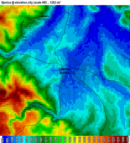
Below is the Elevation map of Sjenica, which displays elevation range with different colors. Scale of the first map is from 985 to 1252 m (3232 to 4108 ft) with average elevation of 1056.9 meters (=3468 ft) [note 1]
These maps also provides idea of topography and contour of this city, they are displayed at different zoom levels. More info about maps, scale and edge coordinates you can find below images.
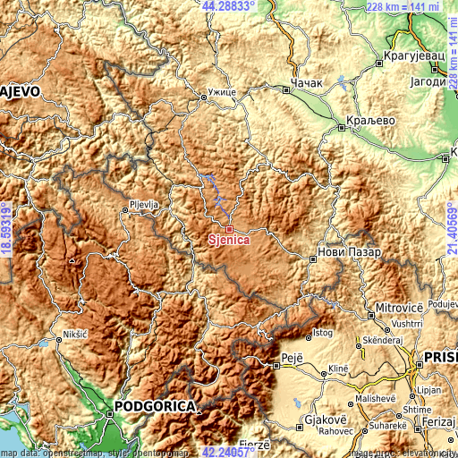
| \ | Map #1 | Topo.Map |
| Scale [m] | 985..1252 m | × |
| Scale [ft] | 3232..4108 ft | × |
| Average | 1056.9 m = 3468 ft | × |
| Width | 7.12 km = 4.4 mi | 227.7 km = 141.5 mi |
| Height | 7.12 km = 4.4 mi | 227.7 km = 141.5 mi |
| ↑Max Latitude | 43.305048° | 44.28833° |
| Latitude at center | 43.27306° | 43.27306° |
| ↓Min Latitude | 43.241055° | 42.24057° |
| ← Min Longitude | 19.955495° | 18.59319° |
| Longitude center | 19.99944° | 19.99944° |
| →Max Longitude | 20.043385° | 21.40569° |
Nearby cities:
Cities around Sjenica sort by population:
• Novi Pazar elevation 511 m
44.2 km,  110°
110°
• Arilje 334 m
53.9 km,  8°
8°
• Zlatibor 980 m
56.1 km,  334°
334°
• Osječenik 1421 m
18.2 km,  218°
218°
• Sokolovo Brdo 1252 m
21.8 km,  226°
226°
• Sokolovica 1000 m
26.4 km,  104°
104°
• Raška 414 m
49.9 km,  88°
88°
• Tutin 869 m
41.4 km,  139°
139°
• Priboj 398 m
51.5 km,  311°
311°
• Prijepolje 452 m
31.2 km,  294°
294°
• Ivanjica 466 m
38.9 km,  28°
28°
• Nova Varoš 987 m
25.8 km,  323°
323°
Multilingual:
 En español:
Sjenica elevación 1011 m.
 En France:
Sjenica élévation 1011 m.
 Auf Deutsch:
Sjenica höhe über dem Meeresspiegel ist 1011 m.

Sources and notes:
- [note 1] Map square and city borders are not equal. Map elevation data is calculated only from area inside that square.
- [src 1] Elevation data from geonames database provided with same terms of usage.
- [src 2] The elevation map of Sjenica is generated using elevation data from NASA's 3 arcsec (90m) resolution SRTM data.
- [src 3] Base (background) map © OpenStreetMap contributors tiles are generated by Geofabrik and OpenTopoMap.
Copyright & License:
This Sjenica Elevation Map is licensed under CC BY-SA. You may reuse any part from this page, if you give a proper credit by linking to this URL:
 More info on terms of use page.