Pećinci elevation
Pećinci (Vojvodina, Srem), Serbia elevation is 83 meters and Pećinci elevation in feet is 272 ft above sea level [src 1]. Pećinci is a seat of a third-order administrative division (feature code) with elevation that is 84 meters (276 ft) smaller than average city elevation in Serbia.
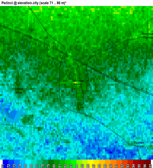
Below is the Elevation map of Pećinci, which displays elevation range with different colors. Scale of the first map is from 71 to 86 m (233 to 282 ft) with average elevation of 77.9 meters (=256 ft) [note 1]
These maps also provides idea of topography and contour of this city, they are displayed at different zoom levels. More info about maps, scale and edge coordinates you can find below images.
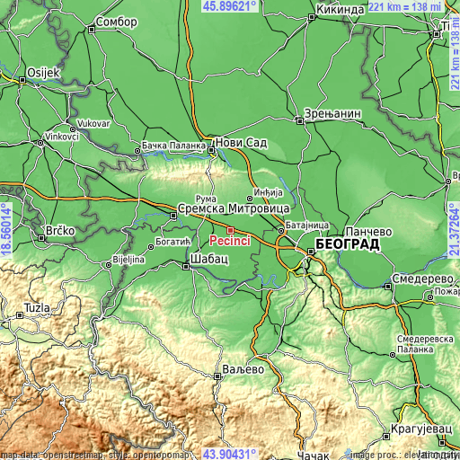
| \ | Map #1 | Topo.Map |
| Scale [m] | 71..86 m | × |
| Scale [ft] | 233..282 ft | × |
| Average | 77.9 m = 256 ft | × |
| Width | 6.92 km = 4.3 mi | 221.5 km = 137.6 mi |
| Height | 6.92 km = 4.3 mi | 221.5 km = 137.6 mi |
| ↑Max Latitude | 44.940005° | 45.89621° |
| Latitude at center | 44.90889° | 44.90889° |
| ↓Min Latitude | 44.877758° | 43.90431° |
| ← Min Longitude | 19.922445° | 18.56014° |
| Longitude center | 19.96639° | 19.96639° |
| →Max Longitude | 20.010335° | 21.37264° |
Nearby cities:
Cities around Pećinci sort by population:
• Ruma elevation 114 m
15.8 km,  314°
314°
• Stara Pazova 81 m
17.5 km,  61°
61°
• Golubinci 88 m
11.4 km,  41°
41°
• Vojka 76 m
15 km,  77°
77°
• Putinci 110 m
9.3 km,  2°
2°
• Hrtkovci 79 m
16.2 km,  259°
259°
• Platičevo 78 m
16.6 km,  234°
234°
• Nikinci 78 m
13 km,  239°
239°
• Šimanovci 76 m
10.6 km,  111°
111°
• Jarak 80 m
16.7 km,  273°
273°
• Buđanovci 78 m
8.3 km, 258°
• Ljukovo 105 m
13.9 km,  20°
20°
Multilingual:
 En español:
Pećinci elevación 83 m.
 En France:
Pećinci élévation 83 m.
 Auf Deutsch:
Opština Pećinci höhe über dem Meeresspiegel ist 83 m.

Sources and notes:
- [note 1] Map square and city borders are not equal. Map elevation data is calculated only from area inside that square.
- [src 1] Elevation data from geonames database provided with same terms of usage.
- [src 2] The elevation map of Pećinci is generated using elevation data from NASA's 3 arcsec (90m) resolution SRTM data.
- [src 3] Base (background) map © OpenStreetMap contributors tiles are generated by Geofabrik and OpenTopoMap.
Copyright & License:
This Pećinci Elevation Map is licensed under CC BY-SA. You may reuse any part from this page, if you give a proper credit by linking to this URL:
 More info on terms of use page.