Ruma elevation
Ruma (Vojvodina, Srem), Serbia elevation is 114 meters and Ruma elevation in feet is 374 ft above sea level [src 1]. Ruma is a seat of a third-order administrative division (feature code) with elevation that is 53 meters (174 ft) smaller than average city elevation in Serbia.
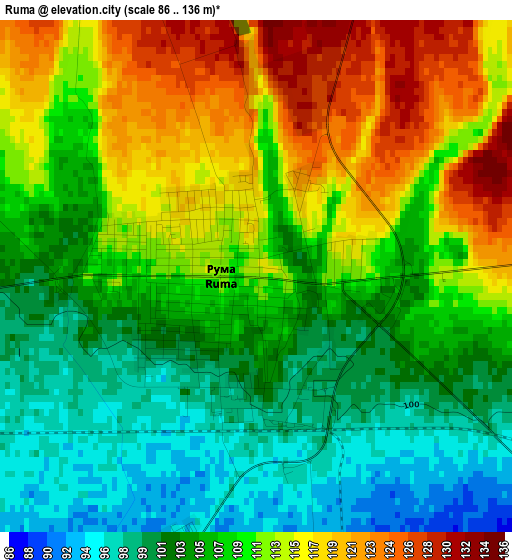
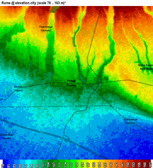
Below is the Elevation map of Ruma, which displays elevation range with different colors. Scale of the first map is from 86 to 136 m (282 to 446 ft) with average elevation of 108.5 meters (=356 ft) [note 1]
These maps also provides idea of topography and contour of this city, they are displayed at different zoom levels. More info about maps, scale and edge coordinates you can find below images.
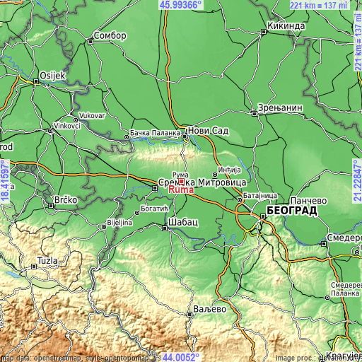
| \ | Map #1 | Map #2 | Topo.Map |
| Scale [m] | 86..136 m | 78..163 m | × |
| Scale [ft] | 282..446 ft | 256..535 ft | × |
| Average | 108.5 m = 356 ft | 110.2 m = 362 ft | × |
| Width | 6.91 km = 4.3 mi | 13.82 km = 8.6 mi | 221.1 km = 137.4 mi |
| Height | 6.91 km = 4.3 mi | 13.82 km = 8.6 mi | 221.1 km = 137.4 mi |
| ↑Max Latitude | 45.039121° | 45.070166° | 45.99366° |
| Latitude at center | 45.00806° | 45.00806° | 45.00806° |
| ↓Min Latitude | 44.976982° | 44.945887° | 44.0052° |
| ← Min Longitude | 19.778275° | 19.734329° | 18.41597° |
| Longitude center | 19.82222° | 19.82222° | 19.82222° |
| →Max Longitude | 19.866165° | 19.910111° | 21.22847° |
Nearby cities:
Cities around Ruma sort by population:
• Sremska Mitrovica elevation 84 m
16.9 km,  257°
257°
• Irig 139 m
5.2 km,  19°
19°
• Vrdnik 197 m
12.9 km,  349°
349°
• Putinci 110 m
11.8 km,  98°
98°
• Hrtkovci 79 m
14.8 km,  198°
198°
• Nikinci 78 m
17.6 km,  179°
179°
• Pećinci 83 m
15.8 km,  134°
134°
• Jarak 80 m
11.3 km,  208°
208°
• Buđanovci 78 m
13.1 km,  165°
165°
• Šašinci 88 m
7.9 km,  233°
233°
• Ljukovo 105 m
16.2 km,  82°
82°
• Irig 185 m
10.7 km, 15°
Multilingual:
 En español:
Ruma elevación 114 m.
 En France:
Ruma élévation 114 m.


Sources and notes:
- [note 1] Map square and city borders are not equal. Map elevation data is calculated only from area inside that square.
- [src 1] Elevation data from geonames database provided with same terms of usage.
- [src 2] The elevation map of Ruma is generated using elevation data from NASA's 3 arcsec (90m) resolution SRTM data.
- [src 3] Base (background) map © OpenStreetMap contributors tiles are generated by Geofabrik and OpenTopoMap.
Copyright & License:
This Ruma Elevation Map is licensed under CC BY-SA. You may reuse any part from this page, if you give a proper credit by linking to this URL:
 More info on terms of use page.