Abrămuţ elevation
Abrămuţ (Bihor, Comuna Abrămuţ), Romania elevation is 119 meters and Abrămuţ elevation in feet is 390 ft above sea level [src 1]. Abrămuţ is a seat of a second-order administrative division (feature code) with elevation that is 133 meters (436 ft) smaller than average city elevation in Romania.
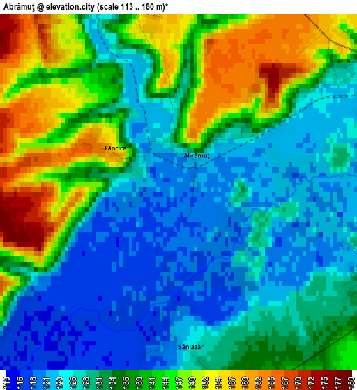
Below is the Elevation map of Abrămuţ, which displays elevation range with different colors. Scale of the first map is from 113 to 180 m (371 to 591 ft) with average elevation of 134.3 meters (=441 ft) [note 1]
These maps also provides idea of topography and contour of this city, they are displayed at different zoom levels. More info about maps, scale and edge coordinates you can find below images.
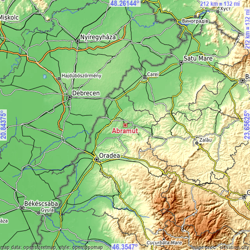
| \ | Map #1 | Topo.Map |
| Scale [m] | 113..180 m | × |
| Scale [ft] | 371..591 ft | × |
| Average | 134.3 m = 441 ft | × |
| Width | 6.63 km = 4.1 mi | 212 km = 131.7 mi |
| Height | 6.63 km = 4.1 mi | 212 km = 131.7 mi |
| ↑Max Latitude | 47.346454° | 48.26144° |
| Latitude at center | 47.31667° | 47.31667° |
| ↓Min Latitude | 47.286869° | 46.3547° |
| ← Min Longitude | 22.206055° | 20.84375° |
| Longitude center | 22.25° | 22.25° |
| →Max Longitude | 22.293945° | 23.65625° |
Nearby cities:
Cities around Abrămuţ sort by population:
• Marghita elevation 140 m
7.3 km,  59°
59°
• Tăuteu 154 m
8.4 km,  131°
131°
• Chişlaz 116 m
3.9 km,  198°
198°
• Abram 130 m
10.1 km,  90°
90°
• Cherechiu 104 m
11.5 km,  310°
310°
• Buduslău 136 m
9.4 km,  7°
7°
• Petreu 127 m
4.2 km, 56°
• Sâniob 124 m
10.9 km,  237°
237°
• Bogei 147 m
10.1 km,  124°
124°
• Cubulcut 179 m
4.8 km,  277°
277°
• Albiș 135 m
8.2 km,  357°
357°
• Mișca 168 m
6 km,  173°
173°
Multilingual:
 En español:
Abrămuţ elevación 119 m.
 En France:
Abrămuţ élévation 119 m.


Sources and notes:
- [note 1] Map square and city borders are not equal. Map elevation data is calculated only from area inside that square.
- [src 1] Elevation data from geonames database provided with same terms of usage.
- [src 2] The elevation map of Abrămuţ is generated using elevation data from NASA's 3 arcsec (90m) resolution SRTM data.
- [src 3] Base (background) map © OpenStreetMap contributors tiles are generated by Geofabrik and OpenTopoMap.
Copyright & License:
This Abrămuţ Elevation Map is licensed under CC BY-SA. You may reuse any part from this page, if you give a proper credit by linking to this URL:
 More info on terms of use page.