Agnita elevation
Agnita (Sibiu, Oraş Agnita), Romania elevation is 464 meters and Agnita elevation in feet is 1522 ft above sea level [src 1]. Agnita is a seat of a second-order administrative division (feature code) with elevation that is 212 meters (696 ft) bigger than average city elevation in Romania.
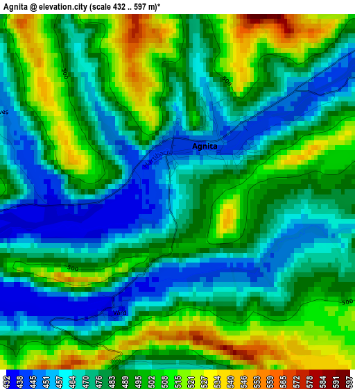
Below is the Elevation map of Agnita, which displays elevation range with different colors. Scale of the first map is from 432 to 597 m (1417 to 1959 ft) with average elevation of 486 meters (=1594 ft) [note 1]
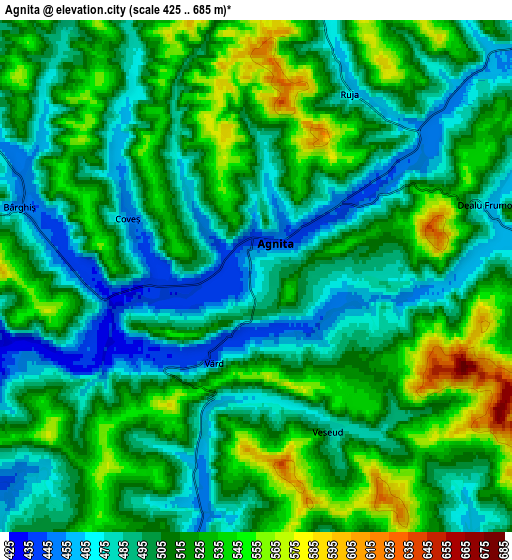
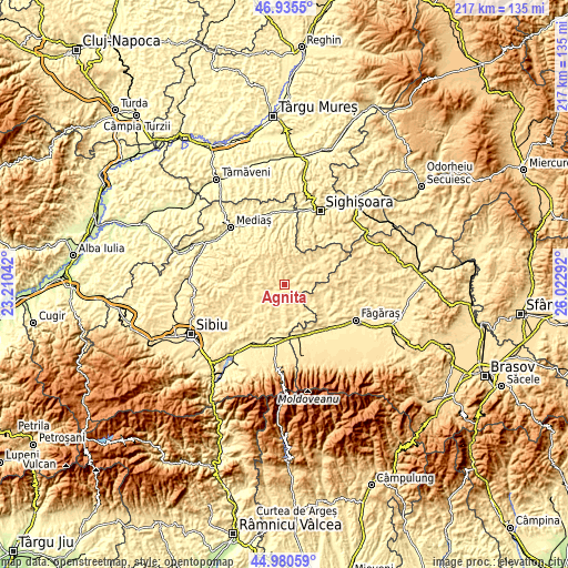
These maps also provides idea of topography and contour of this city, they are displayed at different zoom levels. More info about maps, scale and edge coordinates you can find below images.
| \ | Map #1 | Map #2 | Topo.Map |
| Scale [m] | 432..597 m | 425..685 m | × |
| Scale [ft] | 1417..1959 ft | 1394..2247 ft | × |
| Average | 486 m = 1594 ft | 507.6 m = 1665 ft | × |
| Width | 6.79 km = 4.2 mi | 13.59 km = 8.4 mi | 217.4 km = 135.1 mi |
| Height | 6.79 km = 4.2 mi | 13.59 km = 8.4 mi | 217.4 km = 135.1 mi |
| ↑Max Latitude | 45.997207° | 46.027727° | 46.9355° |
| Latitude at center | 45.96667° | 45.96667° | 45.96667° |
| ↓Min Latitude | 45.936116° | 45.905546° | 44.98059° |
| ← Min Longitude | 24.572725° | 24.528779° | 23.21042° |
| Longitude center | 24.61667° | 24.61667° | 24.61667° |
| →Max Longitude | 24.660615° | 24.704561° | 26.02292° |
Nearby cities:
Cities around Agnita sort by population:
• Biertan elevation 380 m
20.1 km,  337°
337°
• Iacobeni 471 m
12.1 km,  39°
39°
• Nocrich 451 m
14.9 km,  240°
240°
• Cincu 474 m
15.2 km,  111°
111°
• Chirpăr 448 m
7.5 km,  189°
189°
• Merghindeal 469 m
9 km,  90°
90°
• Ruja 463 m
5.7 km,  27°
27°
• Alțâna 417 m
12.2 km,  252°
252°
• Mălâncrav 433 m
16.1 km,  8°
8°
• Marpod 456 m
14.3 km,  219°
219°
• Bruiu 469 m
12.9 km,  149°
149°
• Bârghiş 453 m
6.7 km,  286°
286°
Multilingual:
 En español:
Agnita elevación 464 m.
 En France:
Agnita élévation 464 m.


Sources and notes:
- [note 1] Map square and city borders are not equal. Map elevation data is calculated only from area inside that square.
- [src 1] Elevation data from geonames database provided with same terms of usage.
- [src 2] The elevation map of Agnita is generated using elevation data from NASA's 3 arcsec (90m) resolution SRTM data.
- [src 3] Base (background) map © OpenStreetMap contributors tiles are generated by Geofabrik and OpenTopoMap.
Copyright & License:
This Agnita Elevation Map is licensed under CC BY-SA. You may reuse any part from this page, if you give a proper credit by linking to this URL:
 More info on terms of use page.