Iacobeni elevation
Iacobeni (Sibiu, Comuna Iacobeni), Romania elevation is 471 meters and Iacobeni elevation in feet is 1545 ft above sea level [src 1]. Iacobeni is a seat of a second-order administrative division (feature code) with elevation that is 219 meters (719 ft) bigger than average city elevation in Romania.
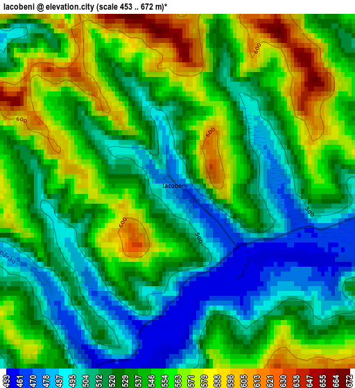
Below is the Elevation map of Iacobeni, which displays elevation range with different colors. Scale of the first map is from 453 to 672 m (1486 to 2205 ft) with average elevation of 535 meters (=1755 ft) [note 1]
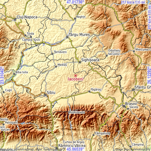
These maps also provides idea of topography and contour of this city, they are displayed at different zoom levels. More info about maps, scale and edge coordinates you can find below images.
| \ | Map #1 | Topo.Map |
| Scale [m] | 453..672 m | × |
| Scale [ft] | 1486..2205 ft | × |
| Average | 535 m = 1755 ft | × |
| Width | 6.78 km = 4.2 mi | 217 km = 134.8 mi |
| Height | 6.78 km = 4.2 mi | 217 km = 134.8 mi |
| ↑Max Latitude | 46.080491° | 47.01736° |
| Latitude at center | 46.05° | 46.05° |
| ↓Min Latitude | 46.019492° | 45.06539° |
| ← Min Longitude | 24.672725° | 23.31042° |
| Longitude center | 24.71667° | 24.71667° |
| →Max Longitude | 24.760615° | 26.12292° |
Nearby cities:
Cities around Iacobeni sort by population:
• Agnita elevation 464 m
12.1 km,  219°
219°
• Daneş 377 m
18.6 km,  356°
356°
• Apold 518 m
10.7 km,  46°
46°
• Biertan 380 m
18 km,  300°
300°
• Cincu 474 m
16.2 km,  156°
156°
• Brădeni 482 m
9.7 km,  67°
67°
• Chirpăr 448 m
19 km,  208°
208°
• Merghindeal 469 m
9.4 km,  172°
172°
• Ruja 463 m
6.6 km,  230°
230°
• Șaeș 398 m
12.5 km,  18°
18°
• Mălâncrav 433 m
8.5 km,  321°
321°
• Bârghiş 453 m
16 km,  242°
242°
Multilingual:
 En español:
Iacobeni elevación 471 m.
 En France:
Iacobeni élévation 471 m.
 Auf Deutsch:
Iacobeni höhe über dem Meeresspiegel ist 471 m.

Sources and notes:
- [note 1] Map square and city borders are not equal. Map elevation data is calculated only from area inside that square.
- [src 1] Elevation data from geonames database provided with same terms of usage.
- [src 2] The elevation map of Iacobeni is generated using elevation data from NASA's 3 arcsec (90m) resolution SRTM data.
- [src 3] Base (background) map © OpenStreetMap contributors tiles are generated by Geofabrik and OpenTopoMap.
Copyright & License:
This Iacobeni Elevation Map is licensed under CC BY-SA. You may reuse any part from this page, if you give a proper credit by linking to this URL:
 More info on terms of use page.