Marpod elevation
Marpod (Sibiu, Comuna Marpod), Romania elevation is 456 meters and Marpod elevation in feet is 1496 ft above sea level [src 1]. Marpod is a seat of a second-order administrative division (feature code) with elevation that is 204 meters (669 ft) bigger than average city elevation in Romania.
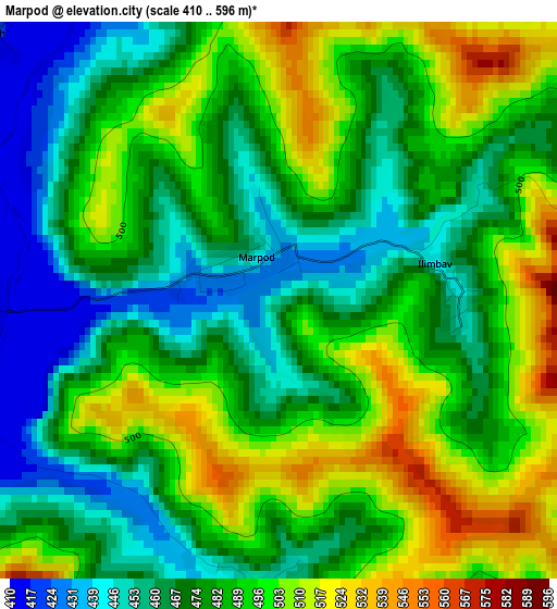
Below is the Elevation map of Marpod, which displays elevation range with different colors. Scale of the first map is from 410 to 596 m (1345 to 1955 ft) with average elevation of 482.2 meters (=1582 ft) [note 1]
These maps also provides idea of topography and contour of this city, they are displayed at different zoom levels. More info about maps, scale and edge coordinates you can find below images.
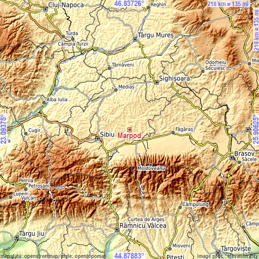
| \ | Map #1 | Topo.Map |
| Scale [m] | 410..596 m | × |
| Scale [ft] | 1345..1955 ft | × |
| Average | 482.2 m = 1582 ft | × |
| Width | 6.8 km = 4.2 mi | 217.8 km = 135.3 mi |
| Height | 6.8 km = 4.2 mi | 217.7 km = 135.3 mi |
| ↑Max Latitude | 45.897262° | 46.83726° |
| Latitude at center | 45.86667° | 45.86667° |
| ↓Min Latitude | 45.836061° | 44.87883° |
| ← Min Longitude | 24.456055° | 23.09375° |
| Longitude center | 24.5° | 24.5° |
| →Max Longitude | 24.543945° | 25.90625° |
Nearby cities:
Cities around Marpod sort by population:
• Agnita elevation 464 m
14.3 km,  39°
39°
• Roşia 426 m
15.3 km,  248°
248°
• Porumbacu de Jos 407 m
13.5 km,  196°
196°
• Arpaşu de Jos 405 m
12.9 km,  135°
135°
• Nocrich 451 m
5.4 km,  313°
313°
• Vurpăr 478 m
12.2 km,  287°
287°
• Chirpăr 448 m
8.6 km,  64°
64°
• Alțâna 417 m
7.8 km,  340°
340°
• Cârţa 406 m
10.6 km,  150°
150°
• Ucea de Jos 428 m
16.1 km,  124°
124°
• Bruiu 469 m
15.5 km,  90°
90°
• Bârghiş 453 m
13.2 km,  11°
11°
Multilingual:
 En español:
Marpod elevación 456 m.
 En France:
Marpod élévation 456 m.


Sources and notes:
- [note 1] Map square and city borders are not equal. Map elevation data is calculated only from area inside that square.
- [src 1] Elevation data from geonames database provided with same terms of usage.
- [src 2] The elevation map of Marpod is generated using elevation data from NASA's 3 arcsec (90m) resolution SRTM data.
- [src 3] Base (background) map © OpenStreetMap contributors tiles are generated by Geofabrik and OpenTopoMap.
Copyright & License:
This Marpod Elevation Map is licensed under CC BY-SA. You may reuse any part from this page, if you give a proper credit by linking to this URL:
 More info on terms of use page.