Aiud elevation
Aiud (Alba, Municipiul Aiud), Romania elevation is 254 meters and Aiud elevation in feet is 833 ft above sea level [src 1]. Aiud is a seat of a second-order administrative division (feature code) with elevation that is 2 meters (7 ft) bigger than average city elevation in Romania.
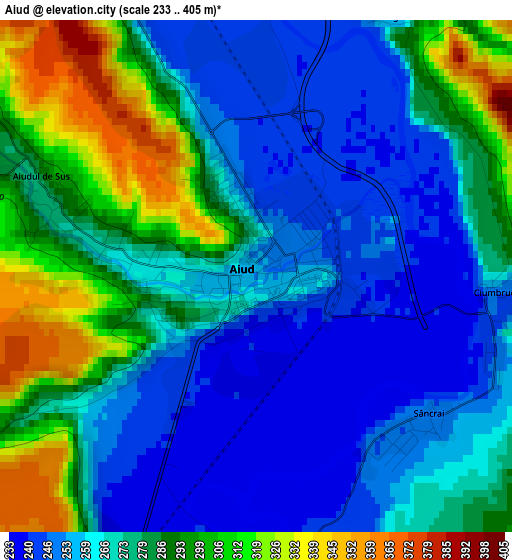
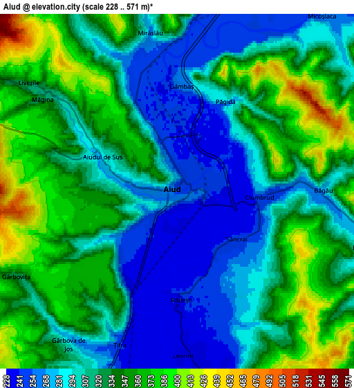
Below is the Elevation map of Aiud, which displays elevation range with different colors. Scale of the first map is from 233 to 405 m (764 to 1329 ft) with average elevation of 274.1 meters (=899 ft) [note 1]
These maps also provides idea of topography and contour of this city, they are displayed at different zoom levels. More info about maps, scale and edge coordinates you can find below images.
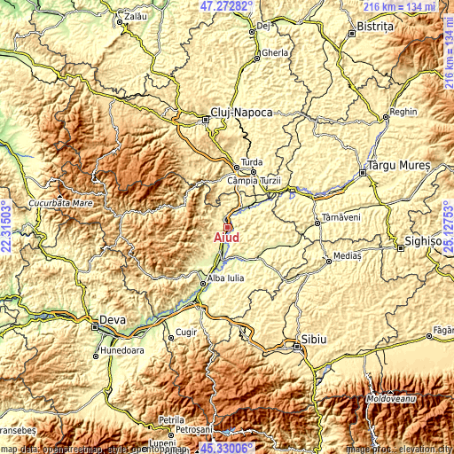
| \ | Map #1 | Map #2 | Topo.Map |
| Scale [m] | 233..405 m | 228..571 m | × |
| Scale [ft] | 764..1329 ft | 748..1873 ft | × |
| Average | 274.1 m = 899 ft | 323.3 m = 1061 ft | × |
| Width | 6.75 km = 4.2 mi | 13.5 km = 8.4 mi | 216 km = 134.2 mi |
| Height | 6.75 km = 4.2 mi | 13.5 km = 8.4 mi | 216 km = 134.2 mi |
| ↑Max Latitude | 46.340407° | 46.370737° | 47.27282° |
| Latitude at center | 46.31006° | 46.31006° | 46.31006° |
| ↓Min Latitude | 46.279696° | 46.249315° | 45.33006° |
| ← Min Longitude | 23.677335° | 23.633389° | 22.31503° |
| Longitude center | 23.72128° | 23.72128° | 23.72128° |
| →Max Longitude | 23.765225° | 23.809171° | 25.12753° |
Nearby cities:
Cities around Aiud sort by population:
• Teiuş elevation 238 m
12.6 km,  193°
193°
• Unirea 276 m
12.6 km,  34°
34°
• Stremţ 337 m
12.4 km,  213°
213°
• Mirăslău 380 m
6.3 km,  356°
356°
• Aiudul de Sus 288 m
2.5 km,  286°
286°
• Ciumbrud 254 m
3.2 km,  93°
93°
• Livezile 361 m
8.1 km,  303°
303°
• Rădeşti 233 m
4.8 km,  184°
184°
• Uioara de Jos 273 m
11.3 km,  53°
53°
• Lopadea Nouă 278 m
7.8 km,  105°
105°
• Sâncrai 247 m
3 km,  127°
127°
• Hopârta 321 m
11.7 km,  83°
83°
Multilingual:
 En español:
Aiud elevación 254 m.
 En France:
Aiud élévation 254 m.
 Auf Deutsch:
Strassburg höhe über dem Meeresspiegel ist 254 m.

Sources and notes:
- [note 1] Map square and city borders are not equal. Map elevation data is calculated only from area inside that square.
- [src 1] Elevation data from geonames database provided with same terms of usage.
- [src 2] The elevation map of Aiud is generated using elevation data from NASA's 3 arcsec (90m) resolution SRTM data.
- [src 3] Base (background) map © OpenStreetMap contributors tiles are generated by Geofabrik and OpenTopoMap.
Copyright & License:
This Aiud Elevation Map is licensed under CC BY-SA. You may reuse any part from this page, if you give a proper credit by linking to this URL:
 More info on terms of use page.