Hopârta elevation
Hopârta (Alba, Comuna Hopârta), Romania elevation is 321 meters and Hopârta elevation in feet is 1053 ft above sea level [src 1]. Hopârta is a seat of a second-order administrative division (feature code) with elevation that is 69 meters (226 ft) bigger than average city elevation in Romania.
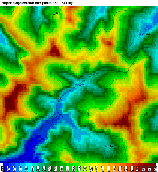
Below is the Elevation map of Hopârta, which displays elevation range with different colors. Scale of the first map is from 277 to 541 m (909 to 1775 ft) with average elevation of 395.1 meters (=1296 ft) [note 1]
These maps also provides idea of topography and contour of this city, they are displayed at different zoom levels. More info about maps, scale and edge coordinates you can find below images.
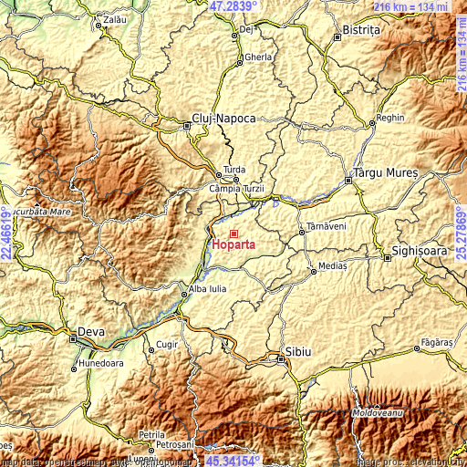
| \ | Map #1 | Topo.Map |
| Scale [m] | 277..541 m | × |
| Scale [ft] | 909..1775 ft | × |
| Average | 395.1 m = 1296 ft | × |
| Width | 6.75 km = 4.2 mi | 216 km = 134.2 mi |
| Height | 6.75 km = 4.2 mi | 216 km = 134.2 mi |
| ↑Max Latitude | 46.351681° | 47.2839° |
| Latitude at center | 46.32134° | 46.32134° |
| ↓Min Latitude | 46.290982° | 45.34154° |
| ← Min Longitude | 23.828495° | 22.46619° |
| Longitude center | 23.87244° | 23.87244° |
| →Max Longitude | 23.916385° | 25.27869° |
Nearby cities:
Cities around Hopârta sort by population:
• Aiud elevation 254 m
11.7 km,  263°
263°
• Ocna Mureş 254 m
7.1 km,  345°
345°
• Unirea 276 m
10.2 km,  333°
333°
• Lunca Mureşului 275 m
12.6 km,  9°
9°
• Mirăslău 380 m
13 km,  292°
292°
• Noşlac 303 m
9.9 km,  28°
28°
• Fărău 316 m
11.2 km,  83°
83°
• Războieni-Cetate 257 m
10.2 km,  359°
359°
• Ciumbrud 254 m
8.6 km, 260°
• Uioara de Jos 273 m
6.1 km, 334°
• Lopadea Nouă 278 m
5.3 km,  230°
230°
• Sâncrai 247 m
9.7 km,  251°
251°
Multilingual:
 En español:
Hopârta elevación 321 m.
 En France:
Hopârta élévation 321 m.


Sources and notes:
- [note 1] Map square and city borders are not equal. Map elevation data is calculated only from area inside that square.
- [src 1] Elevation data from geonames database provided with same terms of usage.
- [src 2] The elevation map of Hopârta is generated using elevation data from NASA's 3 arcsec (90m) resolution SRTM data.
- [src 3] Base (background) map © OpenStreetMap contributors tiles are generated by Geofabrik and OpenTopoMap.
Copyright & License:
This Hopârta Elevation Map is licensed under CC BY-SA. You may reuse any part from this page, if you give a proper credit by linking to this URL:
 More info on terms of use page.