Teiuş elevation
Teiuş (Alba, Oraş Teiuş), Romania elevation is 238 meters and Teiuş elevation in feet is 781 ft above sea level [src 1]. Teiuş is a seat of a second-order administrative division (feature code) with elevation that is 14 meters (46 ft) smaller than average city elevation in Romania.
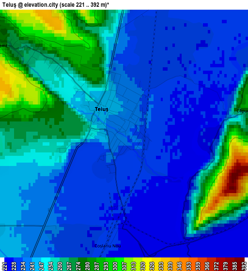
Below is the Elevation map of Teiuş, which displays elevation range with different colors. Scale of the first map is from 221 to 392 m (725 to 1286 ft) with average elevation of 249.2 meters (=818 ft) [note 1]
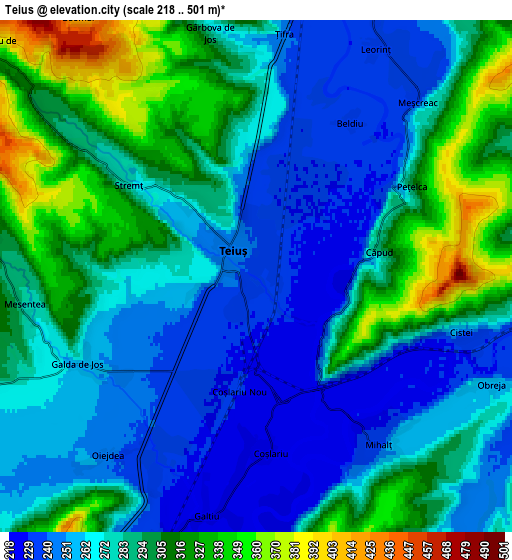
These maps also provides idea of topography and contour of this city, they are displayed at different zoom levels. More info about maps, scale and edge coordinates you can find below images.
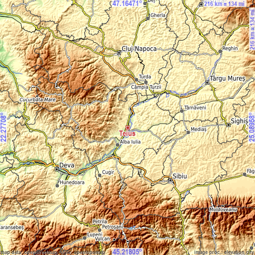
| \ | Map #1 | Map #2 | Topo.Map |
| Scale [m] | 221..392 m | 218..501 m | × |
| Scale [ft] | 725..1286 ft | 715..1644 ft | × |
| Average | 249.2 m = 818 ft | 281.7 m = 924 ft | × |
| Width | 6.76 km = 4.2 mi | 13.53 km = 8.4 mi | 216.4 km = 134.5 mi |
| Height | 6.76 km = 4.2 mi | 13.53 km = 8.4 mi | 216.4 km = 134.5 mi |
| ↑Max Latitude | 46.230408° | 46.260799° | 47.16471° |
| Latitude at center | 46.2° | 46.2° | 46.2° |
| ↓Min Latitude | 46.169575° | 46.139133° | 45.21805° |
| ← Min Longitude | 23.639385° | 23.595439° | 22.27708° |
| Longitude center | 23.68333° | 23.68333° | 23.68333° |
| →Max Longitude | 23.727275° | 23.771221° | 25.08958° |
Nearby cities:
Cities around Teiuş sort by population:
• Aiud elevation 254 m
12.6 km,  13°
13°
• Galda de Jos 266 m
5.5 km,  250°
250°
• Crăciunelu de Jos 262 m
11.7 km,  99°
99°
• Mihalţ 345 m
6.8 km,  145°
145°
• Stremţ 337 m
4.3 km,  295°
295°
• Sântimbru 222 m
7.8 km,  199°
199°
• Aiudul de Sus 288 m
13 km,  2°
2°
• Cricău 397 m
9.2 km,  258°
258°
• Ciumbrud 254 m
13.5 km,  26°
26°
• Rădeşti 233 m
7.8 km,  19°
19°
• Sâncrai 247 m
11.7 km, 26°
• Bucerdea-Grânoasă 265 m
11.5 km,  90°
90°
Multilingual:
 En español:
Teiuş elevación 238 m.
 En France:
Teiuş élévation 238 m.


Sources and notes:
- [note 1] Map square and city borders are not equal. Map elevation data is calculated only from area inside that square.
- [src 1] Elevation data from geonames database provided with same terms of usage.
- [src 2] The elevation map of Teiuş is generated using elevation data from NASA's 3 arcsec (90m) resolution SRTM data.
- [src 3] Base (background) map © OpenStreetMap contributors tiles are generated by Geofabrik and OpenTopoMap.
Copyright & License:
This Teiuş Elevation Map is licensed under CC BY-SA. You may reuse any part from this page, if you give a proper credit by linking to this URL:
 More info on terms of use page.