Crăciunelu de Jos elevation
Crăciunelu de Jos (Alba, Comuna Crăciunelu de Jos), Romania elevation is 262 meters and Crăciunelu de Jos elevation in feet is 860 ft above sea level [src 1]. Crăciunelu de Jos is a seat of a second-order administrative division (feature code) with elevation that is 10 meters (33 ft) bigger than average city elevation in Romania.
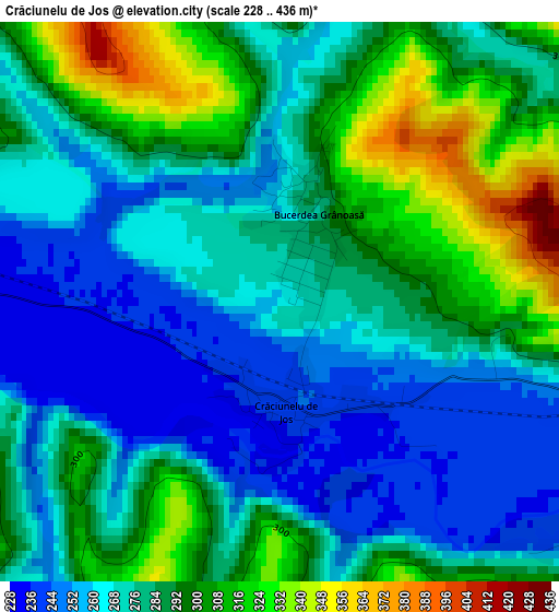
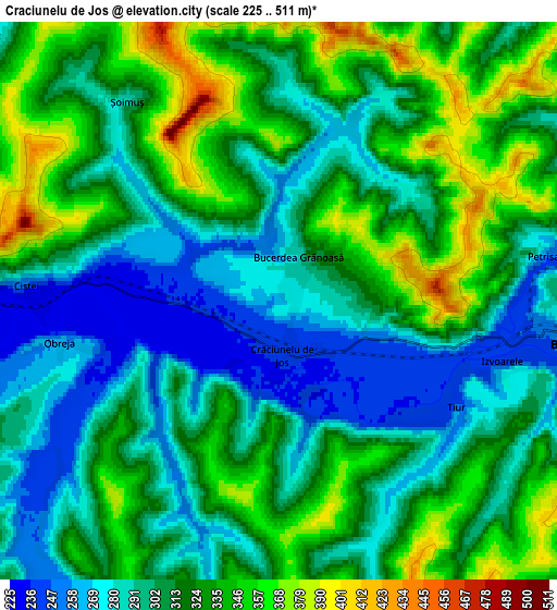
Below is the Elevation map of Crăciunelu de Jos, which displays elevation range with different colors. Scale of the first map is from 228 to 436 m (748 to 1430 ft) with average elevation of 281 meters (=922 ft) [note 1]
These maps also provides idea of topography and contour of this city, they are displayed at different zoom levels. More info about maps, scale and edge coordinates you can find below images.
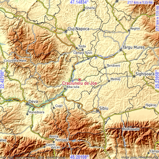
| \ | Map #1 | Map #2 | Topo.Map |
| Scale [m] | 228..436 m | 225..511 m | × |
| Scale [ft] | 748..1430 ft | 738..1677 ft | × |
| Average | 281 m = 922 ft | 313 m = 1027 ft | × |
| Width | 6.77 km = 4.2 mi | 13.53 km = 8.4 mi | 216.5 km = 134.5 mi |
| Height | 6.77 km = 4.2 mi | 13.53 km = 8.4 mi | 216.5 km = 134.5 mi |
| ↑Max Latitude | 46.213747° | 46.244148° | 47.14834° |
| Latitude at center | 46.18333° | 46.18333° | 46.18333° |
| ↓Min Latitude | 46.152896° | 46.122445° | 45.20108° |
| ← Min Longitude | 23.789385° | 23.745439° | 22.42708° |
| Longitude center | 23.83333° | 23.83333° | 23.83333° |
| →Max Longitude | 23.877275° | 23.921221° | 25.23958° |
Nearby cities:
Cities around Crăciunelu de Jos sort by population:
• Blaj elevation 246 m
6.4 km,  98°
98°
• Teiuş 238 m
11.7 km,  279°
279°
• Mihalţ 345 m
8.5 km,  244°
244°
• Sâncel 256 m
9.2 km,  78°
78°
• Izvoarele 242 m
5.6 km,  105°
105°
• Tiur 247 m
5 km,  120°
120°
• Cergău Mic 313 m
13.5 km,  145°
145°
• Veza 245 m
7.3 km, 104°
• Rădeşti 233 m
12.9 km,  315°
315°
• Lopadea Nouă 278 m
12 km,  354°
354°
• Cergău Mare 303 m
11.7 km,  143°
143°
• Bucerdea-Grânoasă 265 m
1.9 km,  0°
0°
Multilingual:
 En español:
Crăciunelu de Jos elevación 262 m.
 En France:
Crăciunelu de Jos élévation 262 m.
 Auf Deutsch:
Crăciunelu de Jos höhe über dem Meeresspiegel ist 262 m.

Sources and notes:
- [note 1] Map square and city borders are not equal. Map elevation data is calculated only from area inside that square.
- [src 1] Elevation data from geonames database provided with same terms of usage.
- [src 2] The elevation map of Crăciunelu de Jos is generated using elevation data from NASA's 3 arcsec (90m) resolution SRTM data.
- [src 3] Base (background) map © OpenStreetMap contributors tiles are generated by Geofabrik and OpenTopoMap.
Copyright & License:
This Crăciunelu de Jos Elevation Map is licensed under CC BY-SA. You may reuse any part from this page, if you give a proper credit by linking to this URL:
 More info on terms of use page.