Tiur elevation
Tiur (Alba, Municipiul Blaj), Romania elevation is 247 meters and Tiur elevation in feet is 810 ft above sea level [src 1]. Tiur is a populated place (feature code) with elevation that is 5 meters (16 ft) smaller than average city elevation in Romania.
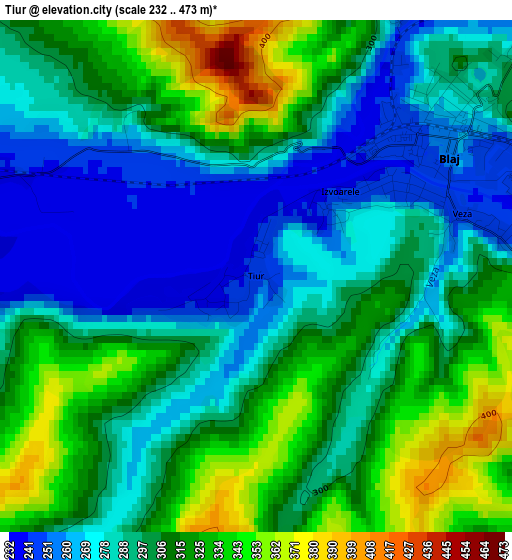
Below is the Elevation map of Tiur, which displays elevation range with different colors. Scale of the first map is from 232 to 473 m (761 to 1552 ft) with average elevation of 300.7 meters (=987 ft) [note 1]
These maps also provides idea of topography and contour of this city, they are displayed at different zoom levels. More info about maps, scale and edge coordinates you can find below images.
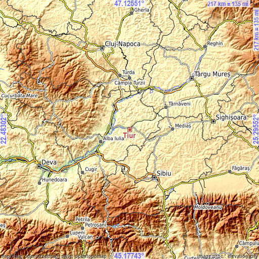
| \ | Map #1 | Topo.Map |
| Scale [m] | 232..473 m | × |
| Scale [ft] | 761..1552 ft | × |
| Average | 300.7 m = 987 ft | × |
| Width | 6.77 km = 4.2 mi | 216.6 km = 134.6 mi |
| Height | 6.77 km = 4.2 mi | 216.6 km = 134.6 mi |
| ↑Max Latitude | 46.19052° | 47.12551° |
| Latitude at center | 46.16009° | 46.16009° |
| ↓Min Latitude | 46.129643° | 45.17743° |
| ← Min Longitude | 23.845325° | 22.48302° |
| Longitude center | 23.88927° | 23.88927° |
| →Max Longitude | 23.933215° | 25.29552° |
Nearby cities:
Cities around Tiur sort by population:
• Blaj elevation 246 m
2.6 km,  50°
50°
• Şona 276 m
11.7 km,  57°
57°
• Crăciunelu de Jos 262 m
5 km,  300°
300°
• Mihalţ 345 m
12.1 km,  264°
264°
• Sâncel 256 m
6.4 km, 46°
• Izvoarele 242 m
1.6 km, 45°
• Cergău Mic 313 m
9.2 km,  158°
158°
• Roşia de Secaş 314 m
12.2 km,  182°
182°
• Veza 245 m
2.8 km,  73°
73°
• Biia 265 m
11.9 km, 48°
• Cergău Mare 303 m
7.3 km, 159°
• Bucerdea-Grânoasă 265 m
6.2 km,  315°
315°
Multilingual:
 En español:
Tiur elevación 247 m.
 En France:
Tiur élévation 247 m.


Sources and notes:
- [note 1] Map square and city borders are not equal. Map elevation data is calculated only from area inside that square.
- [src 1] Elevation data from geonames database provided with same terms of usage.
- [src 2] The elevation map of Tiur is generated using elevation data from NASA's 3 arcsec (90m) resolution SRTM data.
- [src 3] Base (background) map © OpenStreetMap contributors tiles are generated by Geofabrik and OpenTopoMap.
Copyright & License:
This Tiur Elevation Map is licensed under CC BY-SA. You may reuse any part from this page, if you give a proper credit by linking to this URL:
 More info on terms of use page.