Albota elevation
Albota (Arges, Comuna Albota), Romania elevation is 302 meters and Albota elevation in feet is 991 ft above sea level [src 1]. Albota is a seat of a second-order administrative division (feature code) with elevation that is 50 meters (164 ft) bigger than average city elevation in Romania.
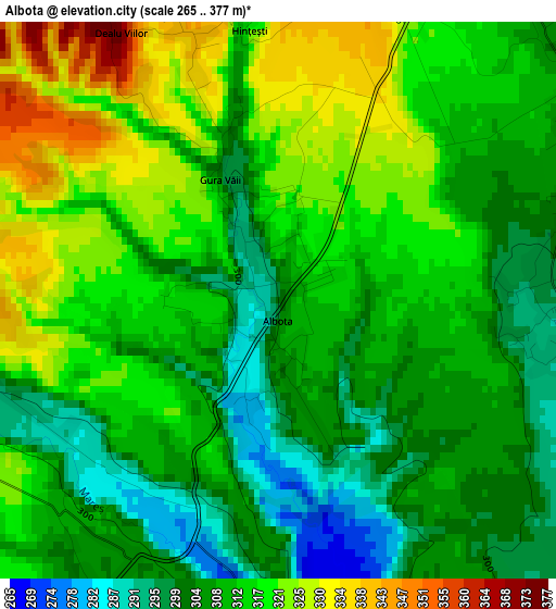
Below is the Elevation map of Albota, which displays elevation range with different colors. Scale of the first map is from 265 to 377 m (869 to 1237 ft) with average elevation of 311.8 meters (=1023 ft) [note 1]
These maps also provides idea of topography and contour of this city, they are displayed at different zoom levels. More info about maps, scale and edge coordinates you can find below images.
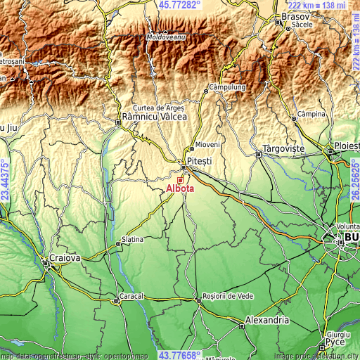
| \ | Map #1 | Topo.Map |
| Scale [m] | 265..377 m | × |
| Scale [ft] | 869..1237 ft | × |
| Average | 311.8 m = 1023 ft | × |
| Width | 6.94 km = 4.3 mi | 222 km = 137.9 mi |
| Height | 6.94 km = 4.3 mi | 222 km = 137.9 mi |
| ↑Max Latitude | 44.814513° | 45.77282° |
| Latitude at center | 44.78333° | 44.78333° |
| ↓Min Latitude | 44.75213° | 43.77658° |
| ← Min Longitude | 24.806055° | 23.44375° |
| Longitude center | 24.85° | 24.85° |
| →Max Longitude | 24.893945° | 26.25625° |
Nearby cities:
Cities around Albota sort by population:
• Piteşti elevation 307 m
7.5 km,  10°
10°
• Poiana Lacului 355 m
9.9 km,  291°
291°
• Bradu 294 m
3.9 km,  90°
90°
• Moşoaia 366 m
7.5 km,  299°
299°
• Albota de Jos 312 m
2.3 km,  215°
215°
• Suseni 257 m
10.8 km,  133°
133°
• Oarja Sat 270 m
9.8 km,  102°
102°
• Oarja 269 m
10.3 km, 104°
• Geamăna 311 m
5.2 km,  38°
38°
• Mareș 310 m
4.8 km,  263°
263°
• Golești 253 m
11 km,  55°
55°
• Mârţeşti 251 m
10.8 km,  226°
226°
Multilingual:
 En español:
Albota elevación 302 m.
 En France:
Albota élévation 302 m.


Sources and notes:
- [note 1] Map square and city borders are not equal. Map elevation data is calculated only from area inside that square.
- [src 1] Elevation data from geonames database provided with same terms of usage.
- [src 2] The elevation map of Albota is generated using elevation data from NASA's 3 arcsec (90m) resolution SRTM data.
- [src 3] Base (background) map © OpenStreetMap contributors tiles are generated by Geofabrik and OpenTopoMap.
Copyright & License:
This Albota Elevation Map is licensed under CC BY-SA. You may reuse any part from this page, if you give a proper credit by linking to this URL:
 More info on terms of use page.