Oarja Sat elevation
Oarja Sat (Arges, Comuna Oarja), Romania elevation is 270 meters and Oarja Sat elevation in feet is 886 ft above sea level [src 1]. Oarja Sat is a populated place (feature code) with elevation that is 18 meters (59 ft) bigger than average city elevation in Romania.
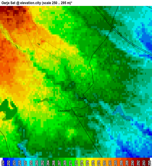
Below is the Elevation map of Oarja Sat, which displays elevation range with different colors. Scale of the first map is from 250 to 295 m (820 to 968 ft) with average elevation of 268.6 meters (=881 ft) [note 1]
These maps also provides idea of topography and contour of this city, they are displayed at different zoom levels. More info about maps, scale and edge coordinates you can find below images.
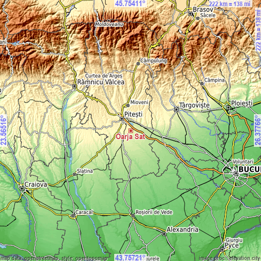
| \ | Map #1 | Topo.Map |
| Scale [m] | 250..295 m | × |
| Scale [ft] | 820..968 ft | × |
| Average | 268.6 m = 881 ft | × |
| Width | 6.94 km = 4.3 mi | 222 km = 137.9 mi |
| Height | 6.94 km = 4.3 mi | 222 km = 137.9 mi |
| ↑Max Latitude | 44.795483° | 45.75411° |
| Latitude at center | 44.76429° | 44.76429° |
| ↓Min Latitude | 44.73308° | 43.75721° |
| ← Min Longitude | 24.927465° | 23.56516° |
| Longitude center | 24.97141° | 24.97141° |
| →Max Longitude | 25.015355° | 26.37766° |
Nearby cities:
Cities around Oarja Sat sort by population:
• Călineşti elevation 240 m
8.5 km,  46°
46°
• Bradu 294 m
6 km,  290°
290°
• Popeşti 241 m
7.5 km,  87°
87°
• Căteasca 238 m
8.8 km, 88°
• Suseni 257 m
5.6 km,  197°
197°
• Oarja 269 m
0.6 km,  139°
139°
• Albota 302 m
9.8 km,  282°
282°
• Geamăna 311 m
8.9 km,  314°
314°
• Șerbănești 242 m
9.4 km,  169°
169°
• Vrănești 273 m
9.5 km,  17°
17°
• Gorganu 267 m
10.2 km,  31°
31°
• Golești 253 m
8.4 km,  356°
356°
Multilingual:
 En español:
Oarja Sat elevación 270 m.
 En France:
Oarja Sat élévation 270 m.
 Auf Deutsch:
Oarja Sat höhe über dem Meeresspiegel ist 270 m.

Sources and notes:
- [note 1] Map square and city borders are not equal. Map elevation data is calculated only from area inside that square.
- [src 1] Elevation data from geonames database provided with same terms of usage.
- [src 2] The elevation map of Oarja Sat is generated using elevation data from NASA's 3 arcsec (90m) resolution SRTM data.
- [src 3] Base (background) map © OpenStreetMap contributors tiles are generated by Geofabrik and OpenTopoMap.
Copyright & License:
This Oarja Sat Elevation Map is licensed under CC BY-SA. You may reuse any part from this page, if you give a proper credit by linking to this URL:
 More info on terms of use page.