Anghelești elevation
Anghelești (Vrancea, Comuna Rugineşti), Romania elevation is 238 meters and Anghelești elevation in feet is 781 ft above sea level [src 1]. Anghelești is a populated place (feature code) with elevation that is 14 meters (46 ft) smaller than average city elevation in Romania.
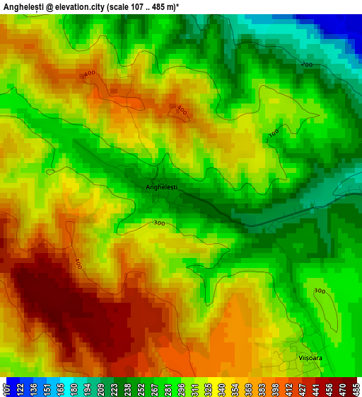
Below is the Elevation map of Anghelești, which displays elevation range with different colors. Scale of the first map is from 107 to 485 m (351 to 1591 ft) with average elevation of 316.4 meters (=1038 ft) [note 1]
These maps also provides idea of topography and contour of this city, they are displayed at different zoom levels. More info about maps, scale and edge coordinates you can find below images.
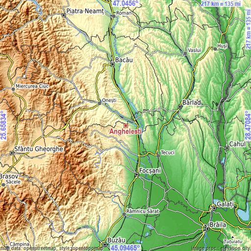
| \ | Map #1 | Topo.Map |
| Scale [m] | 107..485 m | × |
| Scale [ft] | 351..1591 ft | × |
| Average | 316.4 m = 1038 ft | × |
| Width | 6.78 km = 4.2 mi | 216.9 km = 134.8 mi |
| Height | 6.78 km = 4.2 mi | 216.9 km = 134.8 mi |
| ↑Max Latitude | 46.109225° | 47.0456° |
| Latitude at center | 46.07875° | 46.07875° |
| ↓Min Latitude | 46.048258° | 45.09465° |
| ← Min Longitude | 27.020645° | 25.65834° |
| Longitude center | 27.06459° | 27.06459° |
| →Max Longitude | 27.108535° | 28.47084° |
Nearby cities:
Cities around Anghelești sort by population:
• Adjud elevation 101 m
8.2 km,  73°
73°
• Sascut 152 m
13.8 km,  11°
11°
• Păuneşti 261 m
5.7 km,  151°
151°
• Rugineşti 239 m
4.2 km,  108°
108°
• Pufeşti 86 m
13.6 km,  129°
129°
• Urecheşti 121 m
6.2 km, 13°
• Coţofăneşti 169 m
10.1 km,  321°
321°
• Fitioneşti 305 m
10.7 km,  186°
186°
• Sascut-Sat 218 m
12.1 km,  1°
1°
• Adjudu Vechi 103 m
11.4 km,  56°
56°
• Domnești-Târg 98 m
11.5 km, 126°
• Viișoara 299 m
3.9 km,  141°
141°
Multilingual:
 En español:
Anghelești elevación 238 m.
 En France:
Anghelești élévation 238 m.
 Auf Deutsch:
Anghelești höhe über dem Meeresspiegel ist 238 m.

Sources and notes:
- [note 1] Map square and city borders are not equal. Map elevation data is calculated only from area inside that square.
- [src 1] Elevation data from geonames database provided with same terms of usage.
- [src 2] The elevation map of Anghelești is generated using elevation data from NASA's 3 arcsec (90m) resolution SRTM data.
- [src 3] Base (background) map © OpenStreetMap contributors tiles are generated by Geofabrik and OpenTopoMap.
Copyright & License:
This Anghelești Elevation Map is licensed under CC BY-SA. You may reuse any part from this page, if you give a proper credit by linking to this URL:
 More info on terms of use page.