Sascut elevation
Sascut (Bacău, Comuna Sascut), Romania elevation is 152 meters and Sascut elevation in feet is 499 ft above sea level [src 1]. Sascut is a seat of a second-order administrative division (feature code) with elevation that is 100 meters (328 ft) smaller than average city elevation in Romania.
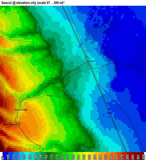
Below is the Elevation map of Sascut, which displays elevation range with different colors. Scale of the first map is from 97 to 309 m (318 to 1014 ft) with average elevation of 161 meters (=528 ft) [note 1]
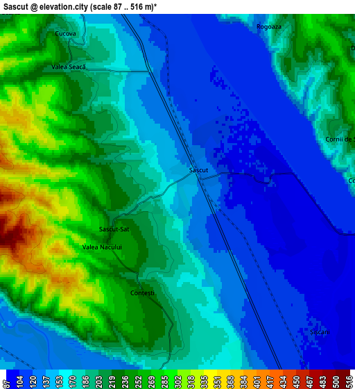
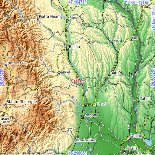
These maps also provides idea of topography and contour of this city, they are displayed at different zoom levels. More info about maps, scale and edge coordinates you can find below images.
| \ | Map #1 | Map #2 | Topo.Map |
| Scale [m] | 97..309 m | 87..516 m | × |
| Scale [ft] | 318..1014 ft | 285..1693 ft | × |
| Average | 161 m = 528 ft | 183.1 m = 601 ft | × |
| Width | 6.76 km = 4.2 mi | 13.53 km = 8.4 mi | 216.4 km = 134.5 mi |
| Height | 6.76 km = 4.2 mi | 13.53 km = 8.4 mi | 216.4 km = 134.5 mi |
| ↑Max Latitude | 46.230408° | 46.260799° | 47.16471° |
| Latitude at center | 46.2° | 46.2° | 46.2° |
| ↓Min Latitude | 46.169575° | 46.139133° | 45.21805° |
| ← Min Longitude | 27.056055° | 27.012109° | 25.69375° |
| Longitude center | 27.1° | 27.1° | 27.1° |
| →Max Longitude | 27.143945° | 27.187891° | 28.50625° |
Nearby cities:
Cities around Sascut sort by population:
• Corbasca elevation 255 m
10.6 km,  28°
28°
• Orbeni 220 m
11.3 km,  325°
325°
• Urecheşti 121 m
7.5 km,  189°
189°
• Coţofăneşti 169 m
10.6 km,  238°
238°
• Păncești 194 m
2.8 km,  296°
296°
• Valea Seacă 199 m
6.3 km,  318°
318°
• Sascut-Sat 218 m
2.8 km, 239°
• Scurta 202 m
9.4 km, 316°
• Adjudu Vechi 103 m
10 km,  136°
136°
• Berești 104 m
3.5 km,  83°
83°
• Lespezi 111 m
11.7 km,  112°
112°
• Tătărăști 227 m
7.9 km, 76°
Multilingual:
 En español:
Sascut elevación 152 m.
 En France:
Sascut élévation 152 m.


Sources and notes:
- [note 1] Map square and city borders are not equal. Map elevation data is calculated only from area inside that square.
- [src 1] Elevation data from geonames database provided with same terms of usage.
- [src 2] The elevation map of Sascut is generated using elevation data from NASA's 3 arcsec (90m) resolution SRTM data.
- [src 3] Base (background) map © OpenStreetMap contributors tiles are generated by Geofabrik and OpenTopoMap.
Copyright & License:
This Sascut Elevation Map is licensed under CC BY-SA. You may reuse any part from this page, if you give a proper credit by linking to this URL:
 More info on terms of use page.