Babadag elevation
Babadag (Tulcea, Oraş Babadag), Romania elevation is 61 meters and Babadag elevation in feet is 200 ft above sea level [src 1]. Babadag is a seat of a second-order administrative division (feature code) with elevation that is 191 meters (627 ft) smaller than average city elevation in Romania.
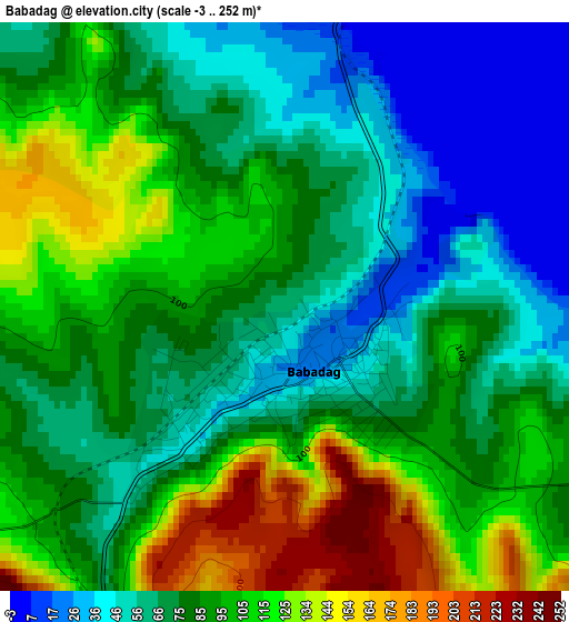
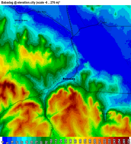
Below is the Elevation map of Babadag, which displays elevation range with different colors. Scale of the first map is from -3 to 252 m (-10 to 827 ft) with average elevation of 85.6 meters (=281 ft) [note 1]
These maps also provides idea of topography and contour of this city, they are displayed at different zoom levels. More info about maps, scale and edge coordinates you can find below images.
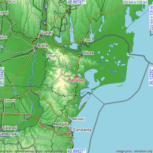
| \ | Map #1 | Map #2 | Topo.Map |
| Scale [m] | -3..252 m | -6..276 m | × |
| Scale [ft] | -10..827 ft | -20..906 ft | × |
| Average | 85.6 m = 281 ft | 88.6 m = 291 ft | × |
| Width | 6.92 km = 4.3 mi | 13.84 km = 8.6 mi | 221.5 km = 137.6 mi |
| Height | 6.92 km = 4.3 mi | 13.84 km = 8.6 mi | 221.5 km = 137.6 mi |
| ↑Max Latitude | 44.93112° | 44.962223° | 45.88747° |
| Latitude at center | 44.9° | 44.9° | 44.9° |
| ↓Min Latitude | 44.868863° | 44.83771° | 43.89527° |
| ← Min Longitude | 28.672725° | 28.628779° | 27.31042° |
| Longitude center | 28.71667° | 28.71667° | 28.71667° |
| →Max Longitude | 28.760615° | 28.804561° | 30.12292° |
Nearby cities:
Cities around Babadag sort by population:
• Sarichioi elevation 35 m
11.9 km,  62°
62°
• Mihail Kogălniceanu 26 m
14.9 km,  5°
5°
• Nalbant 68 m
18.4 km,  334°
334°
• Mihai Bravu 34 m
7.6 km,  316°
316°
• Ceamurlia de Jos -2 m
18.5 km,  180°
180°
• Zebil 14 m
6.6 km,  38°
38°
• Slava Rusă 50 m
10.4 km,  237°
237°
• Turda 18 m
11.1 km, 318°
• Enisala 19 m
8.4 km,  105°
105°
• Nicolae Bălcescu 34 m
14.8 km, 316°
• Ceamurlia de Sus 105 m
17.4 km,  209°
209°
• Slava Cercheză 93 m
13.3 km,  270°
270°
Multilingual:
 En español:
Babadag elevación 61 m.
 En France:
Babadag élévation 61 m.


Sources and notes:
- [note 1] Map square and city borders are not equal. Map elevation data is calculated only from area inside that square.
- [src 1] Elevation data from geonames database provided with same terms of usage.
- [src 2] The elevation map of Babadag is generated using elevation data from NASA's 3 arcsec (90m) resolution SRTM data.
- [src 3] Base (background) map © OpenStreetMap contributors tiles are generated by Geofabrik and OpenTopoMap.
Copyright & License:
This Babadag Elevation Map is licensed under CC BY-SA. You may reuse any part from this page, if you give a proper credit by linking to this URL:
 More info on terms of use page.