Enisala elevation
Enisala (Tulcea, Comuna Sarichioi), Romania elevation is 19 meters and Enisala elevation in feet is 62 ft above sea level [src 1]. Enisala is a populated place (feature code) with elevation that is 233 meters (764 ft) smaller than average city elevation in Romania.
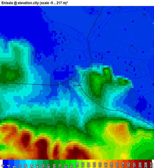
Below is the Elevation map of Enisala, which displays elevation range with different colors. Scale of the first map is from -9 to 217 m (-30 to 712 ft) with average elevation of 41.8 meters (=137 ft) [note 1]
These maps also provides idea of topography and contour of this city, they are displayed at different zoom levels. More info about maps, scale and edge coordinates you can find below images.
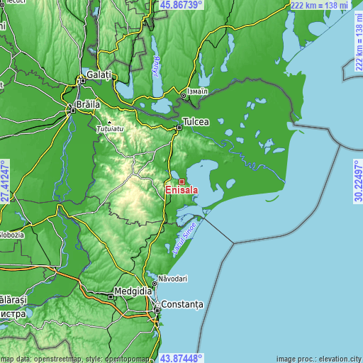
| \ | Map #1 | Topo.Map |
| Scale [m] | -9..217 m | × |
| Scale [ft] | -30..712 ft | × |
| Average | 41.8 m = 137 ft | × |
| Width | 6.92 km = 4.3 mi | 221.6 km = 137.7 mi |
| Height | 6.92 km = 4.3 mi | 221.6 km = 137.7 mi |
| ↑Max Latitude | 44.910691° | 45.86739° |
| Latitude at center | 44.87956° | 44.87956° |
| ↓Min Latitude | 44.848412° | 43.87448° |
| ← Min Longitude | 28.774775° | 27.41247° |
| Longitude center | 28.81872° | 28.81872° |
| →Max Longitude | 28.862665° | 30.22497° |
Nearby cities:
Cities around Enisala sort by population:
• Babadag elevation 61 m
8.4 km,  285°
285°
• Sarichioi 35 m
8.2 km,  17°
17°
• Jurilovca 45 m
13.1 km,  163°
163°
• Mihail Kogălniceanu 26 m
18.4 km,  338°
338°
• Mihai Bravu 34 m
15.4 km,  300°
300°
• Ceamurlia de Jos -2 m
18.1 km,  206°
206°
• Zebil 14 m
8.4 km,  331°
331°
• Agighiol 5 m
17.7 km,  14°
14°
• Slava Rusă 50 m
17.1 km,  259°
259°
• Lunca 3 m
16.7 km,  191°
191°
• Iazurile 1 m
18.6 km,  31°
31°
• Sălcioara 37 m
13.5 km, 157°
Multilingual:
 En español:
Enisala elevación 19 m.
 En France:
Enisala élévation 19 m.


Sources and notes:
- [note 1] Map square and city borders are not equal. Map elevation data is calculated only from area inside that square.
- [src 1] Elevation data from geonames database provided with same terms of usage.
- [src 2] The elevation map of Enisala is generated using elevation data from NASA's 3 arcsec (90m) resolution SRTM data.
- [src 3] Base (background) map © OpenStreetMap contributors tiles are generated by Geofabrik and OpenTopoMap.
Copyright & License:
This Enisala Elevation Map is licensed under CC BY-SA. You may reuse any part from this page, if you give a proper credit by linking to this URL:
 More info on terms of use page.