Iazurile elevation
Iazurile (Tulcea, Comuna Valea Nucarilor), Romania elevation is 1 meters and Iazurile elevation in feet is 3 ft above sea level [src 1]. Iazurile is a populated place (feature code) with elevation that is 251 meters (823 ft) smaller than average city elevation in Romania.
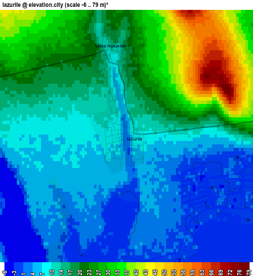
Below is the Elevation map of Iazurile, which displays elevation range with different colors. Scale of the first map is from -6 to 79 m (-20 to 259 ft) with average elevation of 15.3 meters (=50 ft) [note 1]
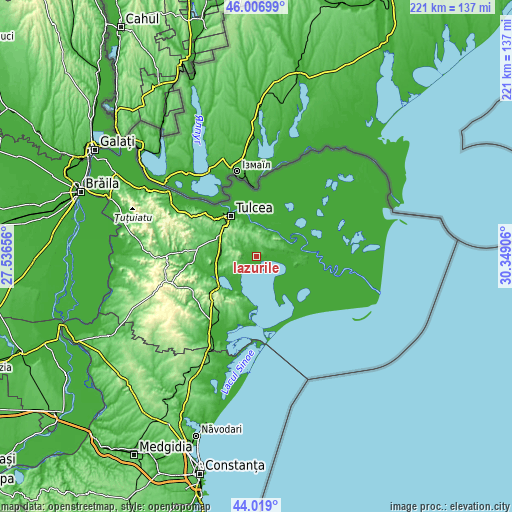
These maps also provides idea of topography and contour of this city, they are displayed at different zoom levels. More info about maps, scale and edge coordinates you can find below images.
| \ | Map #1 | Topo.Map |
| Scale [m] | -6..79 m | × |
| Scale [ft] | -20..259 ft | × |
| Average | 15.3 m = 50 ft | × |
| Width | 6.91 km = 4.3 mi | 221 km = 137.3 mi |
| Height | 6.91 km = 4.3 mi | 221 km = 137.3 mi |
| ↑Max Latitude | 45.052674° | 46.00699° |
| Latitude at center | 45.02162° | 45.02162° |
| ↓Min Latitude | 44.990549° | 44.019° |
| ← Min Longitude | 28.898865° | 27.53656° |
| Longitude center | 28.94281° | 28.94281° |
| →Max Longitude | 28.986755° | 30.34906° |
Nearby cities:
Cities around Iazurile sort by population:
• Sarichioi elevation 35 m
10.8 km,  222°
222°
• Mahmudia 36 m
13 km,  58°
58°
• Valea Nucarilor 15 m
1.5 km,  330°
330°
• Murighiol 11 m
17.6 km,  85°
85°
• Mihail Kogălniceanu 26 m
16.5 km,  274°
274°
• Nufăru 6 m
14.4 km,  351°
351°
• Beștepe 11 m
9.7 km,  35°
35°
• Zebil 14 m
16.1 km,  238°
238°
• Agighiol 5 m
5.4 km,  284°
284°
• Cataloi 31 m
18.7 km,  296°
296°
• Enisala 19 m
18.6 km,  211°
211°
• Malcoci 15 m
13.7 km,  341°
341°
Multilingual:
 En español:
Iazurile elevación 1 m.
 En France:
Iazurile élévation 1 m.


Sources and notes:
- [note 1] Map square and city borders are not equal. Map elevation data is calculated only from area inside that square.
- [src 1] Elevation data from geonames database provided with same terms of usage.
- [src 2] The elevation map of Iazurile is generated using elevation data from NASA's 3 arcsec (90m) resolution SRTM data.
- [src 3] Base (background) map © OpenStreetMap contributors tiles are generated by Geofabrik and OpenTopoMap.
Copyright & License:
This Iazurile Elevation Map is licensed under CC BY-SA. You may reuse any part from this page, if you give a proper credit by linking to this URL:
 More info on terms of use page.