Ceamurlia de Sus elevation
Ceamurlia de Sus (Tulcea, Comuna Baia), Romania elevation is 105 meters and Ceamurlia de Sus elevation in feet is 344 ft above sea level [src 1]. Ceamurlia de Sus is a populated place (feature code) with elevation that is 147 meters (482 ft) smaller than average city elevation in Romania.
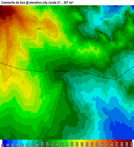
Below is the Elevation map of Ceamurlia de Sus, which displays elevation range with different colors. Scale of the first map is from 21 to 307 m (69 to 1007 ft) with average elevation of 132.2 meters (=434 ft) [note 1]
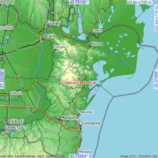
These maps also provides idea of topography and contour of this city, they are displayed at different zoom levels. More info about maps, scale and edge coordinates you can find below images.
| \ | Map #1 | Topo.Map |
| Scale [m] | 21..307 m | × |
| Scale [ft] | 69..1007 ft | × |
| Average | 132.2 m = 434 ft | × |
| Width | 6.94 km = 4.3 mi | 222 km = 137.9 mi |
| Height | 6.94 km = 4.3 mi | 222 km = 137.9 mi |
| ↑Max Latitude | 44.794923° | 45.75356° |
| Latitude at center | 44.76373° | 44.76373° |
| ↓Min Latitude | 44.73252° | 43.75664° |
| ← Min Longitude | 28.564865° | 27.20256° |
| Longitude center | 28.60881° | 28.60881° |
| →Max Longitude | 28.652755° | 30.01506° |
Nearby cities:
Cities around Ceamurlia de Sus sort by population:
• Babadag elevation 61 m
17.4 km,  29°
29°
• Jurilovca 45 m
20.4 km,  89°
89°
• Baia 11 m
6.9 km,  138°
138°
• Casimcea 197 m
19.4 km,  259°
259°
• Mihai Viteazu 77 m
15.6 km,  157°
157°
• Ceamurlia de Jos -2 m
9.2 km,  111°
111°
• Stejaru 182 m
4.7 km,  274°
274°
• Beidaud 95 m
6.2 km,  212°
212°
• Fântânele 111 m
17 km,  188°
188°
• Slava Rusă 50 m
9.6 km,  358°
358°
• Lunca 3 m
13.6 km,  104°
104°
• Slava Cercheză 93 m
16 km,  342°
342°
Multilingual:
 En español:
Ceamurlia de Sus elevación 105 m.
 En France:
Ceamurlia de Sus élévation 105 m.
 Auf Deutsch:
Ceamurlia de Sus höhe über dem Meeresspiegel ist 105 m.

Sources and notes:
- [note 1] Map square and city borders are not equal. Map elevation data is calculated only from area inside that square.
- [src 1] Elevation data from geonames database provided with same terms of usage.
- [src 2] The elevation map of Ceamurlia de Sus is generated using elevation data from NASA's 3 arcsec (90m) resolution SRTM data.
- [src 3] Base (background) map © OpenStreetMap contributors tiles are generated by Geofabrik and OpenTopoMap.
Copyright & License:
This Ceamurlia de Sus Elevation Map is licensed under CC BY-SA. You may reuse any part from this page, if you give a proper credit by linking to this URL:
 More info on terms of use page.