Baia elevation
Baia (Tulcea, Comuna Baia), Romania elevation is 11 meters and Baia elevation in feet is 36 ft above sea level [src 1]. Baia is a seat of a second-order administrative division (feature code) with elevation that is 241 meters (791 ft) smaller than average city elevation in Romania.
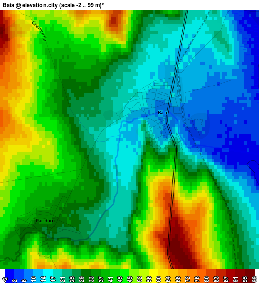
Below is the Elevation map of Baia, which displays elevation range with different colors. Scale of the first map is from -2 to 99 m (-7 to 325 ft) with average elevation of 34.4 meters (=113 ft) [note 1]
These maps also provides idea of topography and contour of this city, they are displayed at different zoom levels. More info about maps, scale and edge coordinates you can find below images.
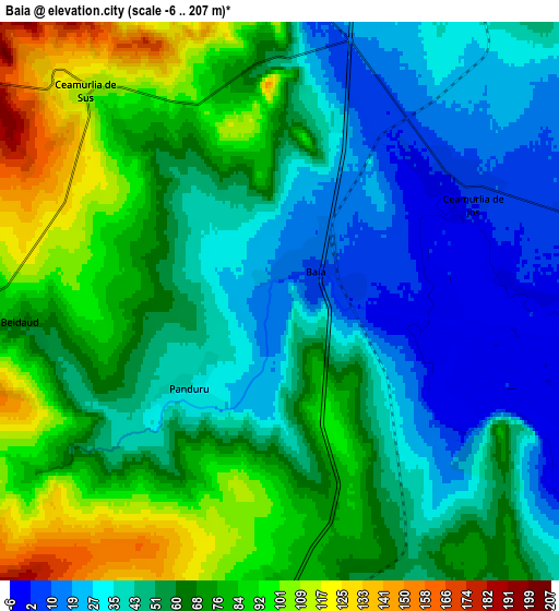
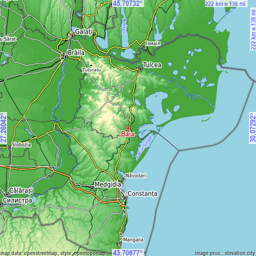
| \ | Map #1 | Map #2 | Topo.Map |
| Scale [m] | -2..99 m | -6..207 m | × |
| Scale [ft] | -7..325 ft | -20..679 ft | × |
| Average | 34.4 m = 113 ft | 58.4 m = 192 ft | × |
| Width | 6.94 km = 4.3 mi | 13.89 km = 8.6 mi | 222.2 km = 138.1 mi |
| Height | 6.94 km = 4.3 mi | 13.89 km = 8.6 mi | 222.2 km = 138.1 mi |
| ↑Max Latitude | 44.747889° | 44.779091° | 45.70732° |
| Latitude at center | 44.71667° | 44.71667° | 44.71667° |
| ↓Min Latitude | 44.685434° | 44.654182° | 43.70877° |
| ← Min Longitude | 28.622725° | 28.578779° | 27.26042° |
| Longitude center | 28.66667° | 28.66667° | 28.66667° |
| →Max Longitude | 28.710615° | 28.754561° | 30.07292° |
Nearby cities:
Cities around Baia sort by population:
• Jurilovca elevation 45 m
16.7 km,  70°
70°
• Mihai Viteazu 77 m
9.4 km,  171°
171°
• Ceamurlia de Jos -2 m
4.4 km,  64°
64°
• Istria 15 m
17.1 km, 166°
• Stejaru 182 m
10.8 km,  301°
301°
• Beidaud 95 m
7.9 km,  270°
270°
• Fântânele 111 m
13.6 km,  211°
211°
• Slava Rusă 50 m
15.6 km,  342°
342°
• Lunca 3 m
8.7 km,  78°
78°
• Tariverde 54 m
17.9 km,  196°
196°
• Sălcioara 37 m
18 km, 72°
• Ceamurlia de Sus 105 m
6.9 km,  318°
318°
Multilingual:
 En español:
Baia elevación 11 m.
 En France:
Baia élévation 11 m.


Sources and notes:
- [note 1] Map square and city borders are not equal. Map elevation data is calculated only from area inside that square.
- [src 1] Elevation data from geonames database provided with same terms of usage.
- [src 2] The elevation map of Baia is generated using elevation data from NASA's 3 arcsec (90m) resolution SRTM data.
- [src 3] Base (background) map © OpenStreetMap contributors tiles are generated by Geofabrik and OpenTopoMap.
Copyright & License:
This Baia Elevation Map is licensed under CC BY-SA. You may reuse any part from this page, if you give a proper credit by linking to this URL:
 More info on terms of use page.