Babeţi elevation
Babeţi (Buzău, Comuna Pănătău), Romania elevation is 299 meters and Babeţi elevation in feet is 981 ft above sea level [src 1]. Babeţi is a section of populated place (feature code) with elevation that is 47 meters (154 ft) bigger than average city elevation in Romania.
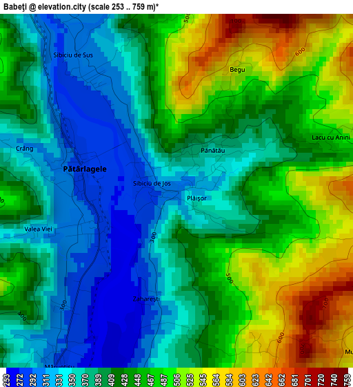
Below is the Elevation map of Babeţi, which displays elevation range with different colors. Scale of the first map is from 253 to 759 m (830 to 2490 ft) with average elevation of 421.1 meters (=1382 ft) [note 1]
These maps also provides idea of topography and contour of this city, they are displayed at different zoom levels. More info about maps, scale and edge coordinates you can find below images.
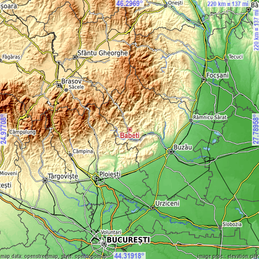
| \ | Map #1 | Topo.Map |
| Scale [m] | 253..759 m | × |
| Scale [ft] | 830..2490 ft | × |
| Average | 421.1 m = 1382 ft | × |
| Width | 6.87 km = 4.3 mi | 219.9 km = 136.6 mi |
| Height | 6.87 km = 4.3 mi | 219.9 km = 136.6 mi |
| ↑Max Latitude | 45.347563° | 46.2969° |
| Latitude at center | 45.31667° | 45.31667° |
| ↓Min Latitude | 45.28576° | 44.31918° |
| ← Min Longitude | 26.339385° | 24.97708° |
| Longitude center | 26.38333° | 26.38333° |
| →Max Longitude | 26.427275° | 27.78958° |
Nearby cities:
Cities around Babeţi sort by population:
• Burueneşti elevation 340 m
2.6 km,  270°
270°
• Cislău 253 m
7.5 km,  189°
189°
• Calvini 324 m
9.9 km,  221°
221°
• Pătârlagele 284 m
1.8 km,  284°
284°
• Cozieni 267 m
8 km,  76°
76°
• Bâscenii de Jos 297 m
9.1 km,  212°
212°
• Colţi 539 m
7.4 km,  0°
0°
• Păltineni 338 m
10 km,  332°
332°
• Mărunțișu 282 m
4.1 km, 213°
• Corbu 413 m
10.5 km, 272°
• Bâscenii de Sus 391 m
10.4 km,  237°
237°
• Pănătău 341 m
1 km,  60°
60°
Multilingual:
 En español:
Babeţi elevación 299 m.
 En France:
Babeţi élévation 299 m.


Sources and notes:
- [note 1] Map square and city borders are not equal. Map elevation data is calculated only from area inside that square.
- [src 1] Elevation data from geonames database provided with same terms of usage.
- [src 2] The elevation map of Babeţi is generated using elevation data from NASA's 3 arcsec (90m) resolution SRTM data.
- [src 3] Base (background) map © OpenStreetMap contributors tiles are generated by Geofabrik and OpenTopoMap.
Copyright & License:
This Babeţi Elevation Map is licensed under CC BY-SA. You may reuse any part from this page, if you give a proper credit by linking to this URL:
 More info on terms of use page.