Corbu elevation
Corbu (Buzău, Comuna Cătina), Romania elevation is 413 meters and Corbu elevation in feet is 1355 ft above sea level [src 1]. Corbu is a populated place (feature code) with elevation that is 161 meters (528 ft) bigger than average city elevation in Romania.
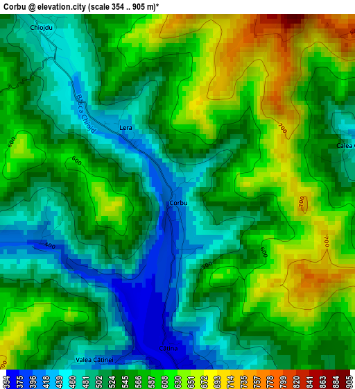
Below is the Elevation map of Corbu, which displays elevation range with different colors. Scale of the first map is from 354 to 905 m (1161 to 2969 ft) with average elevation of 553.3 meters (=1815 ft) [note 1]
These maps also provides idea of topography and contour of this city, they are displayed at different zoom levels. More info about maps, scale and edge coordinates you can find below images.
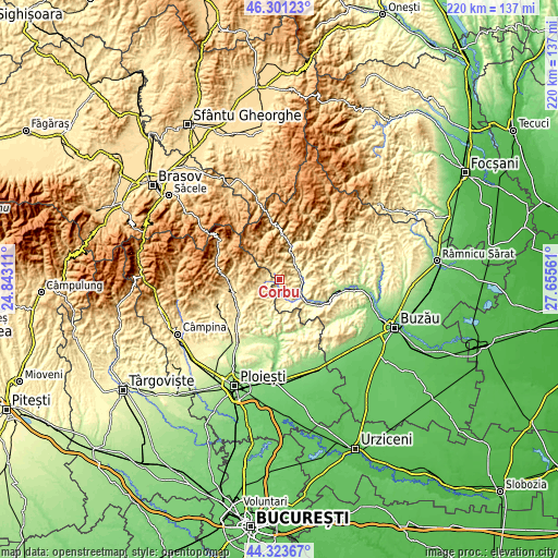
| \ | Map #1 | Topo.Map |
| Scale [m] | 354..905 m | × |
| Scale [ft] | 1161..2969 ft | × |
| Average | 553.3 m = 1815 ft | × |
| Width | 6.87 km = 4.3 mi | 219.9 km = 136.6 mi |
| Height | 6.87 km = 4.3 mi | 219.9 km = 136.6 mi |
| ↑Max Latitude | 45.351971° | 46.30123° |
| Latitude at center | 45.32108° | 45.32108° |
| ↓Min Latitude | 45.290172° | 44.32367° |
| ← Min Longitude | 26.205415° | 24.84311° |
| Longitude center | 26.24936° | 26.24936° |
| →Max Longitude | 26.293305° | 27.65561° |
Nearby cities:
Cities around Corbu sort by population:
• Burueneşti elevation 340 m
7.9 km,  93°
93°
• Starchiojd 449 m
5.2 km,  264°
264°
• Calvini 324 m
8.8 km,  153°
153°
• Chiojdu 598 m
5 km,  309°
309°
• Cătina 482 m
2.3 km,  178°
178°
• Pătârlagele 284 m
8.8 km, 90°
• Bătrâni 498 m
7.7 km, 264°
• Bâscenii de Jos 297 m
10 km, 145°
• Bâsca Chiojdului 526 m
7.6 km,  317°
317°
• Mărunțișu 282 m
9.1 km,  115°
115°
• Bâscenii de Sus 391 m
6.3 km,  164°
164°
• Poseștii-Pământeni 470 m
9.8 km,  232°
232°
Multilingual:
 En español:
Corbu elevación 413 m.
 En France:
Corbu élévation 413 m.


Sources and notes:
- [note 1] Map square and city borders are not equal. Map elevation data is calculated only from area inside that square.
- [src 1] Elevation data from geonames database provided with same terms of usage.
- [src 2] The elevation map of Corbu is generated using elevation data from NASA's 3 arcsec (90m) resolution SRTM data.
- [src 3] Base (background) map © OpenStreetMap contributors tiles are generated by Geofabrik and OpenTopoMap.
Copyright & License:
This Corbu Elevation Map is licensed under CC BY-SA. You may reuse any part from this page, if you give a proper credit by linking to this URL:
 More info on terms of use page.