Cozieni elevation
Cozieni (Buzău, Comuna Cozieni), Romania elevation is 267 meters and Cozieni elevation in feet is 876 ft above sea level [src 1]. Cozieni is a seat of a second-order administrative division (feature code) with elevation that is 15 meters (49 ft) bigger than average city elevation in Romania.
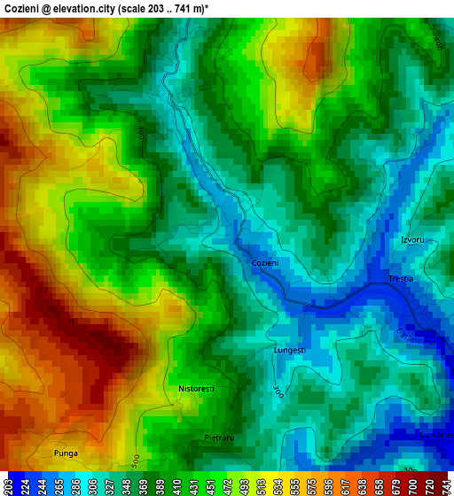
Below is the Elevation map of Cozieni, which displays elevation range with different colors. Scale of the first map is from 203 to 741 m (666 to 2431 ft) with average elevation of 417.5 meters (=1370 ft) [note 1]
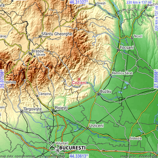
These maps also provides idea of topography and contour of this city, they are displayed at different zoom levels. More info about maps, scale and edge coordinates you can find below images.
| \ | Map #1 | Topo.Map |
| Scale [m] | 203..741 m | × |
| Scale [ft] | 666..2431 ft | × |
| Average | 417.5 m = 1370 ft | × |
| Width | 6.87 km = 4.3 mi | 219.8 km = 136.6 mi |
| Height | 6.87 km = 4.3 mi | 219.8 km = 136.6 mi |
| ↑Max Latitude | 45.364214° | 46.31327° |
| Latitude at center | 45.33333° | 45.33333° |
| ↓Min Latitude | 45.302429° | 44.33613° |
| ← Min Longitude | 26.439385° | 25.07708° |
| Longitude center | 26.48333° | 26.48333° |
| →Max Longitude | 26.527275° | 27.88958° |
Nearby cities:
Cities around Cozieni sort by population:
• Burueneşti elevation 340 m
10.6 km,  259°
259°
• Pârscov 179 m
7.6 km,  136°
136°
• Măgura 249 m
10.8 km,  133°
133°
• Vipereşti 209 m
11.2 km,  186°
186°
• Babeţi 299 m
8 km, 256°
• Pătârlagele 284 m
9.6 km, 261°
• Brăeşti 552 m
11.2 km,  6°
6°
• Colţi 539 m
9.6 km,  305°
305°
• Bozioru 414 m
5.6 km,  0°
0°
• Mărunțișu 282 m
11.4 km,  242°
242°
• Odăile 415 m
7.6 km,  43°
43°
• Pănătău 341 m
7.1 km, 258°
Multilingual:
 En español:
Cozieni elevación 267 m.
 En France:
Cozieni élévation 267 m.


Sources and notes:
- [note 1] Map square and city borders are not equal. Map elevation data is calculated only from area inside that square.
- [src 1] Elevation data from geonames database provided with same terms of usage.
- [src 2] The elevation map of Cozieni is generated using elevation data from NASA's 3 arcsec (90m) resolution SRTM data.
- [src 3] Base (background) map © OpenStreetMap contributors tiles are generated by Geofabrik and OpenTopoMap.
Copyright & License:
This Cozieni Elevation Map is licensed under CC BY-SA. You may reuse any part from this page, if you give a proper credit by linking to this URL:
 More info on terms of use page.