Berca elevation
Berca (Buzău, Comuna Berca), Romania elevation is 147 meters and Berca elevation in feet is 482 ft above sea level [src 1]. Berca is a seat of a second-order administrative division (feature code) with elevation that is 105 meters (344 ft) smaller than average city elevation in Romania.
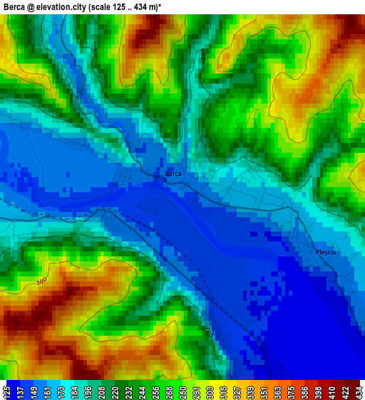
Below is the Elevation map of Berca, which displays elevation range with different colors. Scale of the first map is from 125 to 434 m (410 to 1424 ft) with average elevation of 225 meters (=738 ft) [note 1]
These maps also provides idea of topography and contour of this city, they are displayed at different zoom levels. More info about maps, scale and edge coordinates you can find below images.
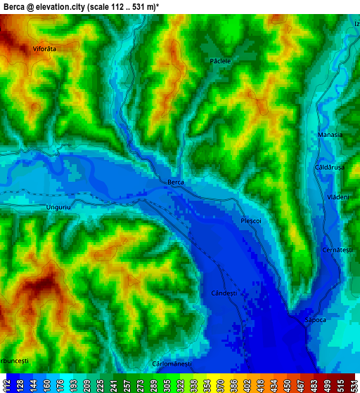
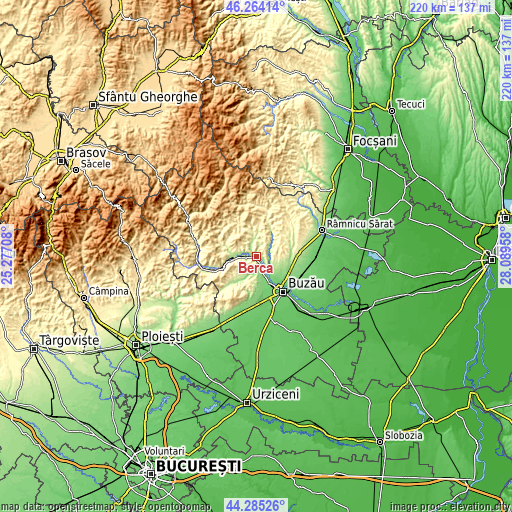
| \ | Map #1 | Map #2 | Topo.Map |
| Scale [m] | 125..434 m | 112..531 m | × |
| Scale [ft] | 410..1424 ft | 367..1742 ft | × |
| Average | 225 m = 738 ft | 247.6 m = 812 ft | × |
| Width | 6.88 km = 4.3 mi | 13.75 km = 8.5 mi | 220 km = 136.7 mi |
| Height | 6.88 km = 4.3 mi | 13.75 km = 8.5 mi | 220 km = 136.7 mi |
| ↑Max Latitude | 45.314242° | 45.345136° | 46.26414° |
| Latitude at center | 45.28333° | 45.28333° | 45.28333° |
| ↓Min Latitude | 45.252402° | 45.221456° | 44.28526° |
| ← Min Longitude | 26.639385° | 26.595439° | 25.27708° |
| Longitude center | 26.68333° | 26.68333° | 26.68333° |
| →Max Longitude | 26.727275° | 26.771221° | 28.08958° |
Nearby cities:
Cities around Berca sort by population:
• Verneşti elevation 121 m
8.4 km,  152°
152°
• Pârscov 179 m
10.4 km,  270°
270°
• Măgura 249 m
8 km,  256°
256°
• Cernăteşti 234 m
6.8 km,  105°
105°
• Scorţoasa 268 m
9.1 km,  349°
349°
• Săpoca 133 m
6.4 km,  125°
125°
• Unguriu 174 m
4 km, 263°
• Mătești 118 m
9.6 km,  143°
143°
• Zărneștii de Slănic 157 m
5.7 km,  97°
97°
• Blăjani 361 m
11.1 km,  70°
70°
• Izvoru Dulce 233 m
9.8 km,  48°
48°
• Grăjdana 164 m
9.3 km,  206°
206°
Multilingual:
 En español:
Berca elevación 147 m.
 En France:
Berca élévation 147 m.


Sources and notes:
- [note 1] Map square and city borders are not equal. Map elevation data is calculated only from area inside that square.
- [src 1] Elevation data from geonames database provided with same terms of usage.
- [src 2] The elevation map of Berca is generated using elevation data from NASA's 3 arcsec (90m) resolution SRTM data.
- [src 3] Base (background) map © OpenStreetMap contributors tiles are generated by Geofabrik and OpenTopoMap.
Copyright & License:
This Berca Elevation Map is licensed under CC BY-SA. You may reuse any part from this page, if you give a proper credit by linking to this URL:
 More info on terms of use page.