Izvoru Dulce elevation
Izvoru Dulce (Buzău, Comuna Beceni), Romania elevation is 233 meters and Izvoru Dulce elevation in feet is 764 ft above sea level [src 1]. Izvoru Dulce is a populated place (feature code) with elevation that is 19 meters (62 ft) smaller than average city elevation in Romania.
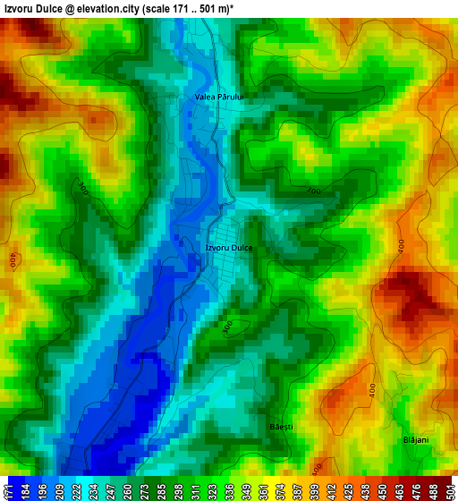
Below is the Elevation map of Izvoru Dulce, which displays elevation range with different colors. Scale of the first map is from 171 to 501 m (561 to 1644 ft) with average elevation of 308.7 meters (=1013 ft) [note 1]
These maps also provides idea of topography and contour of this city, they are displayed at different zoom levels. More info about maps, scale and edge coordinates you can find below images.
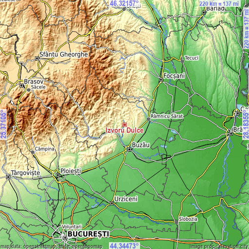
| \ | Map #1 | Topo.Map |
| Scale [m] | 171..501 m | × |
| Scale [ft] | 561..1644 ft | × |
| Average | 308.7 m = 1013 ft | × |
| Width | 6.87 km = 4.3 mi | 219.8 km = 136.6 mi |
| Height | 6.87 km = 4.3 mi | 219.8 km = 136.6 mi |
| ↑Max Latitude | 45.37266° | 46.32157° |
| Latitude at center | 45.34178° | 45.34178° |
| ↓Min Latitude | 45.310883° | 44.34473° |
| ← Min Longitude | 26.733355° | 25.37105° |
| Longitude center | 26.7773° | 26.7773° |
| →Max Longitude | 26.821245° | 28.18355° |
Nearby cities:
Cities around Izvoru Dulce sort by population:
• Berca elevation 147 m
9.8 km,  228°
228°
• Zărneşti 245 m
8.4 km,  123°
123°
• Beceni 311 m
4.6 km,  5°
5°
• Cernăteşti 234 m
8.4 km,  185°
185°
• Scorţoasa 268 m
9.4 km,  285°
285°
• Fundeni 191 m
9.8 km, 124°
• Vadu Sorești 208 m
8.4 km,  110°
110°
• Racoviţeni 324 m
10 km,  73°
73°
• Zărneștii de Slănic 157 m
7.4 km, 193°
• Valea Părului 228 m
2.4 km,  359°
359°
• Blăjani 361 m
4.2 km,  132°
132°
• Pardoşi 324 m
10 km, 73°
Multilingual:
 En español:
Izvoru Dulce elevación 233 m.
 En France:
Izvoru Dulce élévation 233 m.
 Auf Deutsch:
Izvoru Dulce höhe über dem Meeresspiegel ist 233 m.

Sources and notes:
- [note 1] Map square and city borders are not equal. Map elevation data is calculated only from area inside that square.
- [src 1] Elevation data from geonames database provided with same terms of usage.
- [src 2] The elevation map of Izvoru Dulce is generated using elevation data from NASA's 3 arcsec (90m) resolution SRTM data.
- [src 3] Base (background) map © OpenStreetMap contributors tiles are generated by Geofabrik and OpenTopoMap.
Copyright & License:
This Izvoru Dulce Elevation Map is licensed under CC BY-SA. You may reuse any part from this page, if you give a proper credit by linking to this URL:
 More info on terms of use page.