Mătești elevation
Mătești (Buzău, Comuna Săpoca), Romania elevation is 118 meters and Mătești elevation in feet is 387 ft above sea level [src 1]. Mătești is a populated place (feature code) with elevation that is 134 meters (440 ft) smaller than average city elevation in Romania.
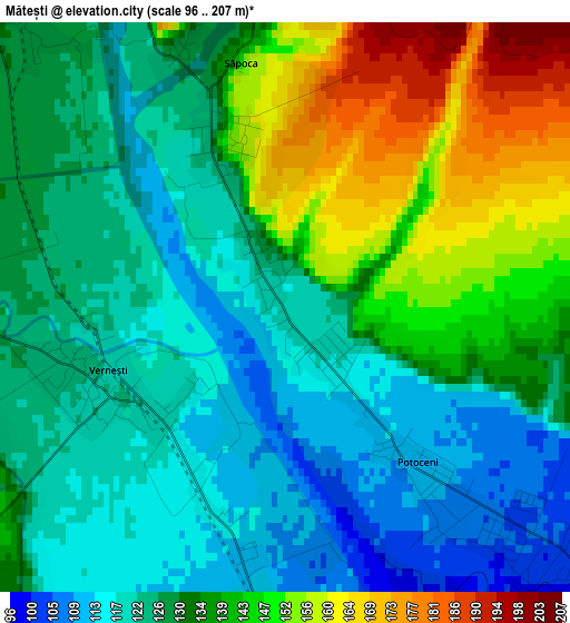
Below is the Elevation map of Mătești, which displays elevation range with different colors. Scale of the first map is from 96 to 207 m (315 to 679 ft) with average elevation of 132.5 meters (=435 ft) [note 1]
These maps also provides idea of topography and contour of this city, they are displayed at different zoom levels. More info about maps, scale and edge coordinates you can find below images.
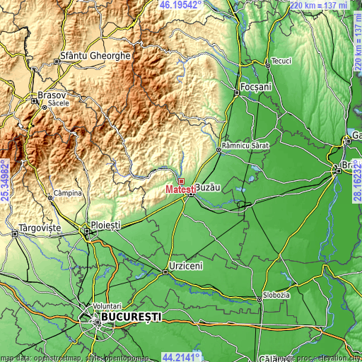
| \ | Map #1 | Topo.Map |
| Scale [m] | 96..207 m | × |
| Scale [ft] | 315..679 ft | × |
| Average | 132.5 m = 435 ft | × |
| Width | 6.88 km = 4.3 mi | 220.3 km = 136.9 mi |
| Height | 6.88 km = 4.3 mi | 220.3 km = 136.9 mi |
| ↑Max Latitude | 45.24434° | 46.19542° |
| Latitude at center | 45.21339° | 45.21339° |
| ↓Min Latitude | 45.182423° | 44.2141° |
| ← Min Longitude | 26.712125° | 25.34982° |
| Longitude center | 26.75607° | 26.75607° |
| →Max Longitude | 26.800015° | 28.16232° |
Nearby cities:
Cities around Mătești sort by population:
• Buzău elevation 93 m
9.3 km,  139°
139°
• Berca 147 m
9.6 km,  323°
323°
• Verneşti 121 m
1.8 km,  281°
281°
• Mărăcineni 125 m
3.7 km,  113°
113°
• Poşta Câlnău 159 m
7.7 km,  73°
73°
• Cernăteşti 234 m
6 km,  7°
7°
• Căpățânești 99 m
4.8 km,  134°
134°
• Săpoca 133 m
4.1 km,  353°
353°
• Lipia 99 m
8.4 km,  191°
191°
• Potoceni 110 m
2.5 km, 139°
• Zărneștii de Slănic 157 m
7.1 km,  359°
359°
• Zorești 146 m
5.5 km,  229°
229°
Multilingual:
 En español:
Mătești elevación 118 m.
 En France:
Mătești élévation 118 m.


Sources and notes:
- [note 1] Map square and city borders are not equal. Map elevation data is calculated only from area inside that square.
- [src 1] Elevation data from geonames database provided with same terms of usage.
- [src 2] The elevation map of Mătești is generated using elevation data from NASA's 3 arcsec (90m) resolution SRTM data.
- [src 3] Base (background) map © OpenStreetMap contributors tiles are generated by Geofabrik and OpenTopoMap.
Copyright & License:
This Mătești Elevation Map is licensed under CC BY-SA. You may reuse any part from this page, if you give a proper credit by linking to this URL:
 More info on terms of use page.