Zorești elevation
Zorești (Buzău, Comuna Verneşti), Romania elevation is 146 meters and Zorești elevation in feet is 479 ft above sea level [src 1]. Zorești is a populated place (feature code) with elevation that is 106 meters (348 ft) smaller than average city elevation in Romania.
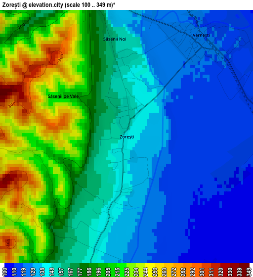
Below is the Elevation map of Zorești, which displays elevation range with different colors. Scale of the first map is from 100 to 349 m (328 to 1145 ft) with average elevation of 165.8 meters (=544 ft) [note 1]
These maps also provides idea of topography and contour of this city, they are displayed at different zoom levels. More info about maps, scale and edge coordinates you can find below images.
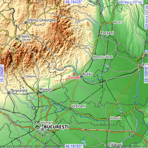
| \ | Map #1 | Topo.Map |
| Scale [m] | 100..349 m | × |
| Scale [ft] | 328..1145 ft | × |
| Average | 165.8 m = 544 ft | × |
| Width | 6.89 km = 4.3 mi | 220.4 km = 136.9 mi |
| Height | 6.89 km = 4.3 mi | 220.4 km = 136.9 mi |
| ↑Max Latitude | 45.212737° | 46.16435° |
| Latitude at center | 45.18177° | 45.18177° |
| ↓Min Latitude | 45.150786° | 44.18193° |
| ← Min Longitude | 26.658965° | 25.29666° |
| Longitude center | 26.70291° | 26.70291° |
| →Max Longitude | 26.746855° | 28.10916° |
Nearby cities:
Cities around Zorești sort by population:
• Buzău elevation 93 m
10.8 km,  109°
109°
• Verneşti 121 m
4.6 km,  31°
31°
• Merei 136 m
5.6 km,  195°
195°
• Mărăcineni 125 m
7.9 km,  75°
75°
• Cernăteşti 234 m
10.7 km, 27°
• Căpățânești 99 m
7.6 km,  88°
88°
• Săpoca 133 m
8.4 km, 25°
• Lipia 99 m
5.3 km,  151°
151°
• Potoceni 110 m
6 km,  74°
74°
• Mătești 118 m
5.5 km,  49°
49°
• Grăjdana 164 m
6.4 km,  297°
297°
• Izvoru 179 m
8.8 km,  277°
277°
Multilingual:
 En español:
Zorești elevación 146 m.
 En France:
Zorești élévation 146 m.


Sources and notes:
- [note 1] Map square and city borders are not equal. Map elevation data is calculated only from area inside that square.
- [src 1] Elevation data from geonames database provided with same terms of usage.
- [src 2] The elevation map of Zorești is generated using elevation data from NASA's 3 arcsec (90m) resolution SRTM data.
- [src 3] Base (background) map © OpenStreetMap contributors tiles are generated by Geofabrik and OpenTopoMap.
Copyright & License:
This Zorești Elevation Map is licensed under CC BY-SA. You may reuse any part from this page, if you give a proper credit by linking to this URL:
 More info on terms of use page.