Bârnova elevation
Bârnova (Iaşi, Comuna Bârnova), Romania elevation is 154 meters and Bârnova elevation in feet is 505 ft above sea level [src 1]. Bârnova is a seat of a second-order administrative division (feature code) with elevation that is 98 meters (322 ft) smaller than average city elevation in Romania.
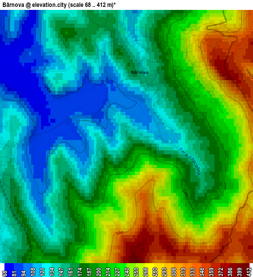
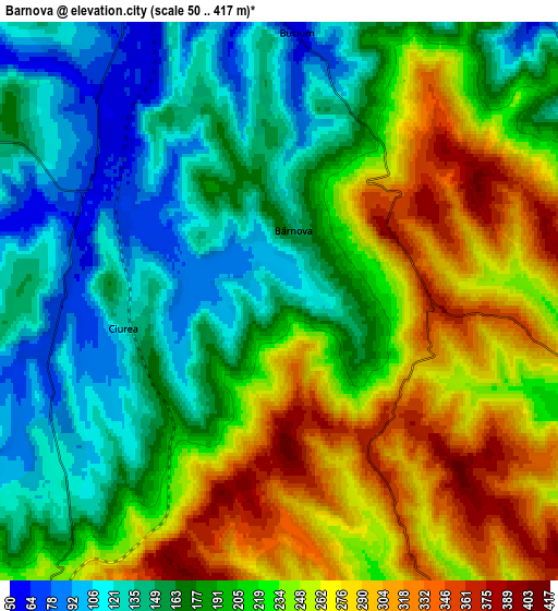
Below is the Elevation map of Bârnova, which displays elevation range with different colors. Scale of the first map is from 68 to 412 m (223 to 1352 ft) with average elevation of 192 meters (=630 ft) [note 1]
These maps also provides idea of topography and contour of this city, they are displayed at different zoom levels. More info about maps, scale and edge coordinates you can find below images.
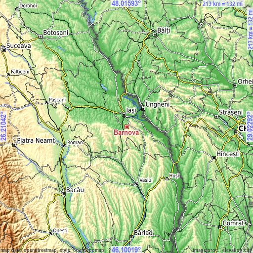
| \ | Map #1 | Map #2 | Topo.Map |
| Scale [m] | 68..412 m | 50..417 m | × |
| Scale [ft] | 223..1352 ft | 164..1368 ft | × |
| Average | 192 m = 630 ft | 206.8 m = 678 ft | × |
| Width | 6.66 km = 4.1 mi | 13.31 km = 8.3 mi | 213 km = 132.4 mi |
| Height | 6.66 km = 4.1 mi | 13.31 km = 8.3 mi | 213 km = 132.4 mi |
| ↑Max Latitude | 47.096595° | 47.126503° | 48.01593° |
| Latitude at center | 47.06667° | 47.06667° | 47.06667° |
| ↓Min Latitude | 47.036728° | 47.00677° | 46.10019° |
| ← Min Longitude | 27.572725° | 27.528779° | 26.21042° |
| Longitude center | 27.61667° | 27.61667° | 27.61667° |
| →Max Longitude | 27.660615° | 27.704561° | 29.02292° |
Nearby cities:
Cities around Bârnova sort by population:
• Iaşi elevation 66 m
11.2 km,  353°
353°
• Tomeşti 152 m
7.5 km,  42°
42°
• Holboca 52 m
11.2 km,  34°
34°
• Ciurea 92 m
4.2 km,  243°
243°
• Miroslava 128 m
12 km,  320°
320°
• Dancu 56 m
10.4 km,  21°
21°
• Mogoşeşti 89 m
7.3 km, 239°
• Comarna 162 m
12.8 km,  98°
98°
• Schitu-Duca 194 m
12 km,  108°
108°
• Lunca Cetățuii 65 m
5.2 km,  309°
309°
• Dumbrava 77 m
5 km,  281°
281°
• Goruni 113 m
8.8 km,  61°
61°
Multilingual:
 En español:
Bârnova elevación 154 m.
 En France:
Bârnova élévation 154 m.


Sources and notes:
- [note 1] Map square and city borders are not equal. Map elevation data is calculated only from area inside that square.
- [src 1] Elevation data from geonames database provided with same terms of usage.
- [src 2] The elevation map of Bârnova is generated using elevation data from NASA's 3 arcsec (90m) resolution SRTM data.
- [src 3] Base (background) map © OpenStreetMap contributors tiles are generated by Geofabrik and OpenTopoMap.
Copyright & License:
This Bârnova Elevation Map is licensed under CC BY-SA. You may reuse any part from this page, if you give a proper credit by linking to this URL:
 More info on terms of use page.