Comarna elevation
Comarna (Iaşi, Comuna Comarna), Romania elevation is 162 meters and Comarna elevation in feet is 531 ft above sea level [src 1]. Comarna is a seat of a second-order administrative division (feature code) with elevation that is 90 meters (295 ft) smaller than average city elevation in Romania.
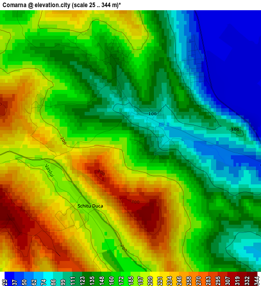
Below is the Elevation map of Comarna, which displays elevation range with different colors. Scale of the first map is from 25 to 344 m (82 to 1129 ft) with average elevation of 165.5 meters (=543 ft) [note 1]
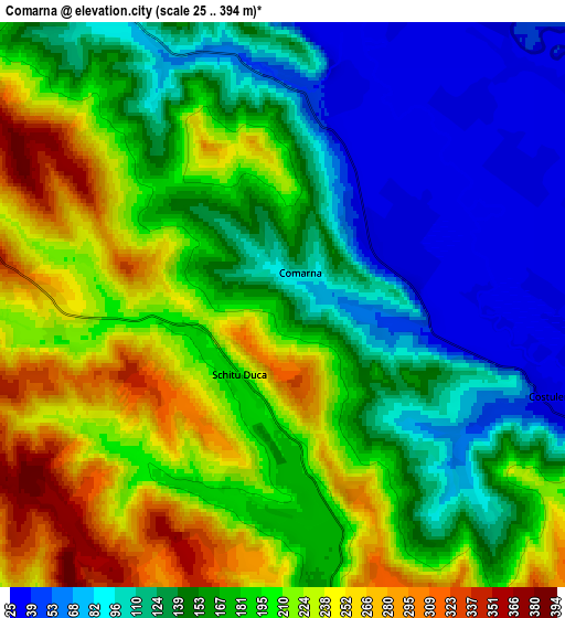
These maps also provides idea of topography and contour of this city, they are displayed at different zoom levels. More info about maps, scale and edge coordinates you can find below images.
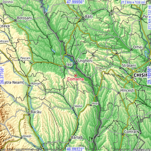
| \ | Map #1 | Map #2 | Topo.Map |
| Scale [m] | 25..344 m | 25..394 m | × |
| Scale [ft] | 82..1129 ft | 82..1293 ft | × |
| Average | 165.5 m = 543 ft | 166.9 m = 548 ft | × |
| Width | 6.66 km = 4.1 mi | 13.32 km = 8.3 mi | 213.1 km = 132.4 mi |
| Height | 6.66 km = 4.1 mi | 13.32 km = 8.3 mi | 213.1 km = 132.4 mi |
| ↑Max Latitude | 47.079934° | 47.109852° | 47.99956° |
| Latitude at center | 47.05° | 47.05° | 47.05° |
| ↓Min Latitude | 47.020049° | 46.990081° | 46.08323° |
| ← Min Longitude | 27.739385° | 27.695439° | 26.37708° |
| Longitude center | 27.78333° | 27.78333° | 27.78333° |
| →Max Longitude | 27.827275° | 27.871221° | 29.18958° |
Nearby cities:
Cities around Comarna sort by population:
• Tomeşti elevation 152 m
10.6 km,  314°
314°
• Costuleni 96 m
5.4 km,  110°
110°
• Schitu-Duca 194 m
2.2 km,  214°
214°
• Bârnova 154 m
12.8 km,  278°
278°
• Prisăcani 33 m
8.4 km,  63°
63°
• Dobrovăţ 265 m
12.8 km, 209°
• Ţuţora 31 m
9.3 km,  0°
0°
• Osoi 37 m
5.2 km,  14°
14°
• Covasna 114 m
7.4 km,  135°
135°
• Coropceni 248 m
12.7 km,  161°
161°
• Goruni 113 m
7.7 km,  320°
320°
• Cozia 160 m
9.9 km,  121°
121°
Multilingual:
 En español:
Comarna elevación 162 m.
 En France:
Comarna élévation 162 m.


Sources and notes:
- [note 1] Map square and city borders are not equal. Map elevation data is calculated only from area inside that square.
- [src 1] Elevation data from geonames database provided with same terms of usage.
- [src 2] The elevation map of Comarna is generated using elevation data from NASA's 3 arcsec (90m) resolution SRTM data.
- [src 3] Base (background) map © OpenStreetMap contributors tiles are generated by Geofabrik and OpenTopoMap.
Copyright & License:
This Comarna Elevation Map is licensed under CC BY-SA. You may reuse any part from this page, if you give a proper credit by linking to this URL:
 More info on terms of use page.