Iaşi elevation
Iaşi, Romania elevation is 66 meters and Iaşi elevation in feet is 217 ft above sea level [src 1]. Iaşi is a seat of a first-order administrative division (feature code) with elevation that is 186 meters (610 ft) smaller than average city elevation in Romania.
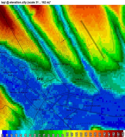
Below is the Elevation map of Iaşi, which displays elevation range with different colors. Scale of the first map is from 31 to 162 m (102 to 531 ft) with average elevation of 74.3 meters (=244 ft) [note 1]
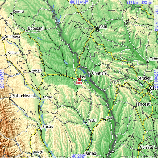
These maps also provides idea of topography and contour of this city, they are displayed at different zoom levels. More info about maps, scale and edge coordinates you can find below images.

| \ | Map #1 | Map #2 | Topo.Map |
| Scale [m] | 31..162 m | 30..349 m | × |
| Scale [ft] | 102..531 ft | 98..1145 ft | × |
| Average | 74.3 m = 244 ft | 99.5 m = 326 ft | × |
| Width | 6.64 km = 4.1 mi | 13.29 km = 8.3 mi | 212.6 km = 132.1 mi |
| Height | 6.64 km = 4.1 mi | 13.29 km = 8.3 mi | 212.6 km = 132.1 mi |
| ↑Max Latitude | 47.196539° | 47.22639° | 48.11414° |
| Latitude at center | 47.16667° | 47.16667° | 47.16667° |
| ↓Min Latitude | 47.136785° | 47.106882° | 46.202° |
| ← Min Longitude | 27.556055° | 27.512109° | 26.19375° |
| Longitude center | 27.6° | 27.6° | 27.6° |
| →Max Longitude | 27.643945° | 27.687891° | 29.00625° |
Nearby cities:
Cities around Iaşi sort by population:
• Tomeşti elevation 152 m
8.4 km,  131°
131°
• Holboca 52 m
7.8 km,  103°
103°
• Miroslava 128 m
6.6 km,  253°
253°
• Dancu 56 m
5.2 km,  105°
105°
• Rediu 142 m
9.4 km,  306°
306°
• Lunca Cetățuii 65 m
8.3 km,  199°
199°
• Aroneanu 115 m
3.7 km,  0°
0°
• Valea Lupului 91 m
7.7 km,  280°
280°
• Golăiești 36 m
10.6 km,  45°
45°
• Vânători 69 m
9 km,  325°
325°
• Dumbrava 77 m
10.7 km, 199°
• Breazu 90 m
8.1 km, 310°
Multilingual:
 En español:
Iași elevación 66 m.
 En France:
Iași élévation 66 m.


Sources and notes:
- [note 1] Map square and city borders are not equal. Map elevation data is calculated only from area inside that square.
- [src 1] Elevation data from geonames database provided with same terms of usage.
- [src 2] The elevation map of Iaşi is generated using elevation data from NASA's 3 arcsec (90m) resolution SRTM data.
- [src 3] Base (background) map © OpenStreetMap contributors tiles are generated by Geofabrik and OpenTopoMap.
Copyright & License:
This Iaşi Elevation Map is licensed under CC BY-SA. You may reuse any part from this page, if you give a proper credit by linking to this URL:
 More info on terms of use page.