Bobulești elevation
Bobulești (Botoşani, Oraş Ştefãneşti), Romania elevation is 66 meters and Bobulești elevation in feet is 217 ft above sea level [src 1]. Bobulești is a populated place (feature code) with elevation that is 186 meters (610 ft) smaller than average city elevation in Romania.
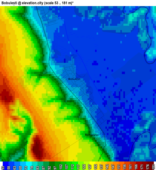
Below is the Elevation map of Bobulești, which displays elevation range with different colors. Scale of the first map is from 53 to 181 m (174 to 594 ft) with average elevation of 89.4 meters (=293 ft) [note 1]
These maps also provides idea of topography and contour of this city, they are displayed at different zoom levels. More info about maps, scale and edge coordinates you can find below images.
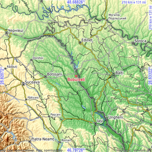
| \ | Map #1 | Topo.Map |
| Scale [m] | 53..181 m | × |
| Scale [ft] | 174..594 ft | × |
| Average | 89.4 m = 293 ft | × |
| Width | 6.57 km = 4.1 mi | 210.3 km = 130.7 mi |
| Height | 6.57 km = 4.1 mi | 210.2 km = 130.6 mi |
| ↑Max Latitude | 47.780888° | 48.68826° |
| Latitude at center | 47.75135° | 47.75135° |
| ↓Min Latitude | 47.721795° | 46.79726° |
| ← Min Longitude | 27.183025° | 25.82072° |
| Longitude center | 27.22697° | 27.22697° |
| →Max Longitude | 27.270915° | 28.63322° |
Nearby cities:
Cities around Bobulești sort by population:
• Albeşti elevation 64 m
13.3 km,  244°
244°
• Truşeşti 106 m
15.8 km,  276°
276°
• Ştefăneşti-Sat 131 m
4.8 km,  317°
317°
• Durneşti 183 m
9.6 km, 280°
• Călăraşi 176 m
15.3 km,  168°
168°
• Todireni 55 m
17.1 km,  208°
208°
• Dobârceni 195 m
14 km,  301°
301°
• Românești 64 m
2.4 km,  155°
155°
• Victoria 100 m
16.3 km,  195°
195°
• Tudor Vladimirescu 136 m
8.3 km, 209°
• Ștefănești 68 m
4.9 km,  336°
336°
• Santa Mare 102 m
17.6 km,  148°
148°
Multilingual:
 En español:
Bobulești elevación 66 m.
 En France:
Bobulești élévation 66 m.
 Auf Deutsch:
Bobulești höhe über dem Meeresspiegel ist 66 m.

Sources and notes:
- [note 1] Map square and city borders are not equal. Map elevation data is calculated only from area inside that square.
- [src 1] Elevation data from geonames database provided with same terms of usage.
- [src 2] The elevation map of Bobulești is generated using elevation data from NASA's 3 arcsec (90m) resolution SRTM data.
- [src 3] Base (background) map © OpenStreetMap contributors tiles are generated by Geofabrik and OpenTopoMap.
Copyright & License:
This Bobulești Elevation Map is licensed under CC BY-SA. You may reuse any part from this page, if you give a proper credit by linking to this URL:
 More info on terms of use page.