Truşeşti elevation
Truşeşti (Botoşani, Comuna Truşeşti), Romania elevation is 106 meters and Truşeşti elevation in feet is 348 ft above sea level [src 1]. Truşeşti is a seat of a second-order administrative division (feature code) with elevation that is 146 meters (479 ft) smaller than average city elevation in Romania.
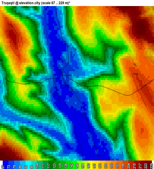
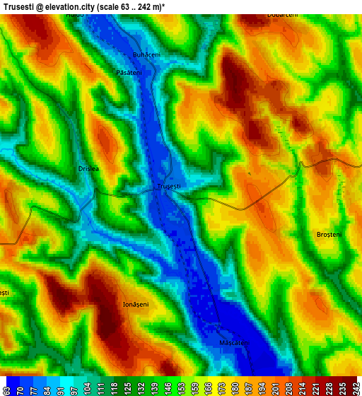
Below is the Elevation map of Truşeşti, which displays elevation range with different colors. Scale of the first map is from 67 to 229 m (220 to 751 ft) with average elevation of 135.4 meters (=444 ft) [note 1]
These maps also provides idea of topography and contour of this city, they are displayed at different zoom levels. More info about maps, scale and edge coordinates you can find below images.
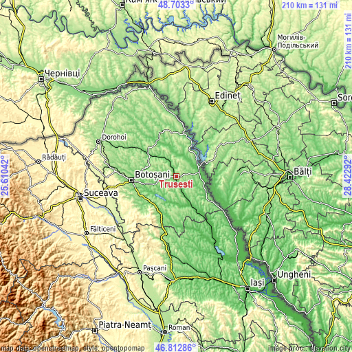
| \ | Map #1 | Map #2 | Topo.Map |
| Scale [m] | 67..229 m | 63..242 m | × |
| Scale [ft] | 220..751 ft | 207..794 ft | × |
| Average | 135.4 m = 444 ft | 149.5 m = 490 ft | × |
| Width | 6.57 km = 4.1 mi | 13.14 km = 8.2 mi | 210.2 km = 130.6 mi |
| Height | 6.57 km = 4.1 mi | 13.14 km = 8.2 mi | 210.2 km = 130.6 mi |
| ↑Max Latitude | 47.7962° | 47.825712° | 48.7033° |
| Latitude at center | 47.76667° | 47.76667° | 47.76667° |
| ↓Min Latitude | 47.737124° | 47.707561° | 46.81286° |
| ← Min Longitude | 26.972725° | 26.928779° | 25.61042° |
| Longitude center | 27.01667° | 27.01667° | 27.01667° |
| →Max Longitude | 27.060615° | 27.104561° | 28.42292° |
Nearby cities:
Cities around Truşeşti sort by population:
• Albeşti elevation 64 m
8.3 km,  153°
153°
• Ştefăneşti-Sat 131 m
12.6 km,  81°
81°
• Durneşti 183 m
6.2 km,  90°
90°
• Gorbăneşti 213 m
12.6 km,  278°
278°
• Dângeni 85 m
10 km,  338°
338°
• Dobârceni 195 m
6.7 km,  33°
33°
• Mihălăşeni 90 m
13.5 km,  16°
16°
• Zlătunoaia 169 m
13 km,  183°
183°
• Ștefănești 68 m
14 km, 78°
• Ionășeni 194 m
4.4 km,  203°
203°
• Iacobeni 94 m
13 km,  323°
323°
• Blândeşti 161 m
13.4 km,  236°
236°
Multilingual:
 En español:
Truşeşti elevación 106 m.
 En France:
Truşeşti élévation 106 m.
 Auf Deutsch:
Truşeşti höhe über dem Meeresspiegel ist 106 m.

Sources and notes:
- [note 1] Map square and city borders are not equal. Map elevation data is calculated only from area inside that square.
- [src 1] Elevation data from geonames database provided with same terms of usage.
- [src 2] The elevation map of Truşeşti is generated using elevation data from NASA's 3 arcsec (90m) resolution SRTM data.
- [src 3] Base (background) map © OpenStreetMap contributors tiles are generated by Geofabrik and OpenTopoMap.
Copyright & License:
This Truşeşti Elevation Map is licensed under CC BY-SA. You may reuse any part from this page, if you give a proper credit by linking to this URL:
 More info on terms of use page.