Todireni elevation
Todireni (Botoşani, Comuna Todireni), Romania elevation is 55 meters and Todireni elevation in feet is 180 ft above sea level [src 1]. Todireni is a seat of a second-order administrative division (feature code) with elevation that is 197 meters (646 ft) smaller than average city elevation in Romania.
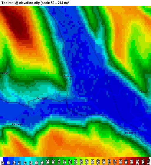
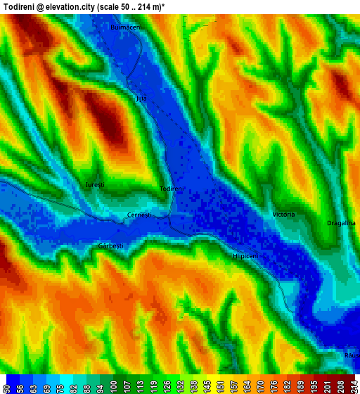
Below is the Elevation map of Todireni, which displays elevation range with different colors. Scale of the first map is from 52 to 214 m (171 to 702 ft) with average elevation of 107.6 meters (=353 ft) [note 1]
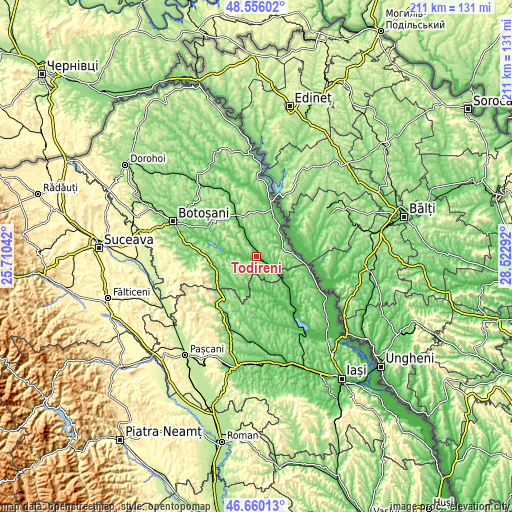
These maps also provides idea of topography and contour of this city, they are displayed at different zoom levels. More info about maps, scale and edge coordinates you can find below images.
| \ | Map #1 | Map #2 | Topo.Map |
| Scale [m] | 52..214 m | 50..214 m | × |
| Scale [ft] | 171..702 ft | 164..702 ft | × |
| Average | 107.6 m = 353 ft | 122 m = 400 ft | × |
| Width | 6.59 km = 4.1 mi | 13.18 km = 8.2 mi | 210.8 km = 131 mi |
| Height | 6.59 km = 4.1 mi | 13.18 km = 8.2 mi | 210.8 km = 131 mi |
| ↑Max Latitude | 47.646285° | 47.675882° | 48.55602° |
| Latitude at center | 47.61667° | 47.61667° | 47.61667° |
| ↓Min Latitude | 47.587039° | 47.55739° | 46.66013° |
| ← Min Longitude | 27.072725° | 27.028779° | 25.71042° |
| Longitude center | 27.11667° | 27.11667° | 27.11667° |
| →Max Longitude | 27.160615° | 27.204561° | 28.52292° |
Nearby cities:
Cities around Todireni sort by population:
• Albeşti elevation 64 m
10 km,  337°
337°
• Lunca 105 m
10 km,  270°
270°
• Călăraşi 176 m
11.2 km,  90°
90°
• Hlipiceni 56 m
3.1 km,  126°
126°
• Plugari 62 m
14.9 km,  184°
184°
• Prăjeni 176 m
13.4 km,  214°
214°
• Răuseni 53 m
8.4 km, 131°
• Zlătunoaia 169 m
9 km,  294°
294°
• Dracșani 110 m
14 km,  275°
275°
• Victoria 100 m
3.9 km,  100°
100°
• Tudor Vladimirescu 136 m
8.8 km,  28°
28°
• Stroiești 101 m
11.3 km, 266°
Multilingual:
 En español:
Todireni elevación 55 m.
 En France:
Todireni élévation 55 m.


Sources and notes:
- [note 1] Map square and city borders are not equal. Map elevation data is calculated only from area inside that square.
- [src 1] Elevation data from geonames database provided with same terms of usage.
- [src 2] The elevation map of Todireni is generated using elevation data from NASA's 3 arcsec (90m) resolution SRTM data.
- [src 3] Base (background) map © OpenStreetMap contributors tiles are generated by Geofabrik and OpenTopoMap.
Copyright & License:
This Todireni Elevation Map is licensed under CC BY-SA. You may reuse any part from this page, if you give a proper credit by linking to this URL:
 More info on terms of use page.