Boureni elevation
Boureni (Iaşi, Comuna Moţca), Romania elevation is 285 meters and Boureni elevation in feet is 935 ft above sea level [src 1]. Boureni is a populated place (feature code) with elevation that is 33 meters (108 ft) bigger than average city elevation in Romania.
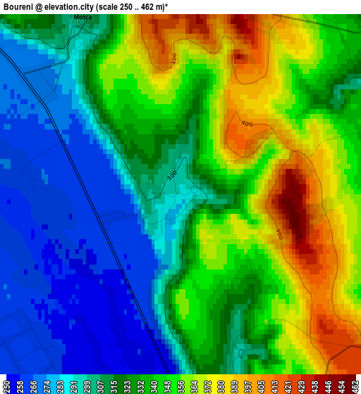
Below is the Elevation map of Boureni, which displays elevation range with different colors. Scale of the first map is from 250 to 462 m (820 to 1516 ft) with average elevation of 326.9 meters (=1073 ft) [note 1]
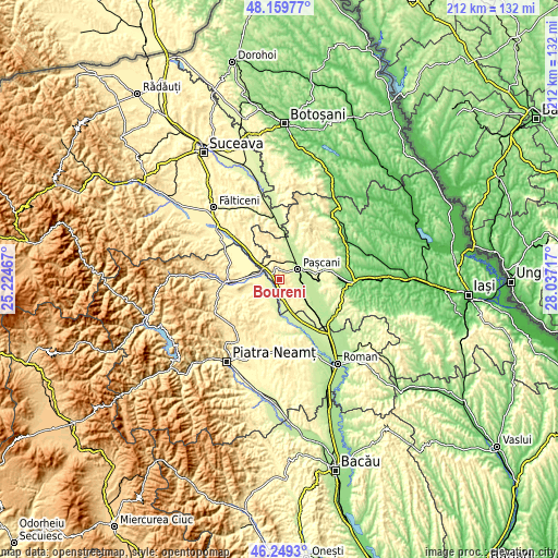
These maps also provides idea of topography and contour of this city, they are displayed at different zoom levels. More info about maps, scale and edge coordinates you can find below images.
| \ | Map #1 | Topo.Map |
| Scale [m] | 250..462 m | × |
| Scale [ft] | 820..1516 ft | × |
| Average | 326.9 m = 1073 ft | × |
| Width | 6.64 km = 4.1 mi | 212.4 km = 132 mi |
| Height | 6.64 km = 4.1 mi | 212.4 km = 132 mi |
| ↑Max Latitude | 47.242982° | 48.15977° |
| Latitude at center | 47.21314° | 47.21314° |
| ↓Min Latitude | 47.183281° | 46.2493° |
| ← Min Longitude | 26.586975° | 25.22467° |
| Longitude center | 26.63092° | 26.63092° |
| →Max Longitude | 26.674865° | 28.03717° |
Nearby cities:
Cities around Boureni sort by population:
• Paşcani elevation 242 m
7.9 km,  61°
61°
• Stolniceni-Prăjescu 239 m
9 km,  100°
100°
• Moţca 360 m
4.2 km,  345°
345°
• Cristeşti 328 m
7.7 km,  320°
320°
• Timişeşti 277 m
6.5 km,  290°
290°
• Păstrăveni 268 m
7.1 km,  223°
223°
• Topile 292 m
6.3 km,  27°
27°
• Miroslovești 274 m
7.2 km,  168°
168°
• Brătești 341 m
4.8 km,  120°
120°
• Valea Seacă 253 m
9.2 km,  17°
17°
• Soci 296 m
3.2 km,  161°
161°
• Sodomeni 300 m
4.4 km,  76°
76°
Multilingual:
 En español:
Boureni elevación 285 m.
 En France:
Boureni élévation 285 m.


Sources and notes:
- [note 1] Map square and city borders are not equal. Map elevation data is calculated only from area inside that square.
- [src 1] Elevation data from geonames database provided with same terms of usage.
- [src 2] The elevation map of Boureni is generated using elevation data from NASA's 3 arcsec (90m) resolution SRTM data.
- [src 3] Base (background) map © OpenStreetMap contributors tiles are generated by Geofabrik and OpenTopoMap.
Copyright & License:
This Boureni Elevation Map is licensed under CC BY-SA. You may reuse any part from this page, if you give a proper credit by linking to this URL:
 More info on terms of use page.