Timişeşti elevation
Timişeşti (Neamţ, Comuna Timişeşti), Romania elevation is 277 meters and Timişeşti elevation in feet is 909 ft above sea level [src 1]. Timişeşti is a seat of a second-order administrative division (feature code) with elevation that is 25 meters (82 ft) bigger than average city elevation in Romania.
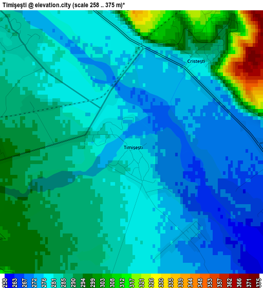
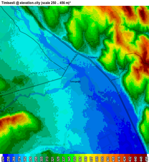
Below is the Elevation map of Timişeşti, which displays elevation range with different colors. Scale of the first map is from 258 to 375 m (846 to 1230 ft) with average elevation of 283.1 meters (=929 ft) [note 1]
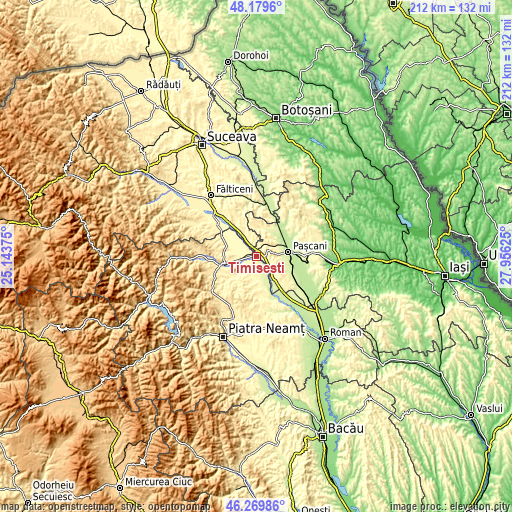
These maps also provides idea of topography and contour of this city, they are displayed at different zoom levels. More info about maps, scale and edge coordinates you can find below images.
| \ | Map #1 | Map #2 | Topo.Map |
| Scale [m] | 258..375 m | 250..456 m | × |
| Scale [ft] | 846..1230 ft | 820..1496 ft | × |
| Average | 283.1 m = 929 ft | 306.8 m = 1007 ft | × |
| Width | 6.64 km = 4.1 mi | 13.27 km = 8.2 mi | 212.3 km = 131.9 mi |
| Height | 6.64 km = 4.1 mi | 13.27 km = 8.2 mi | 212.3 km = 131.9 mi |
| ↑Max Latitude | 47.263161° | 47.292975° | 48.1796° |
| Latitude at center | 47.23333° | 47.23333° | 47.23333° |
| ↓Min Latitude | 47.203482° | 47.173617° | 46.26986° |
| ← Min Longitude | 26.506055° | 26.462109° | 25.14375° |
| Longitude center | 26.55° | 26.55° | 26.55° |
| →Max Longitude | 26.593945° | 26.637891° | 27.95625° |
Nearby cities:
Cities around Timişeşti sort by population:
• Petricani elevation 304 m
9.7 km,  220°
220°
• Moţca 360 m
5.4 km,  69°
69°
• Cristeşti 328 m
3.9 km,  18°
18°
• Urecheni 326 m
7.8 km,  198°
198°
• Păstrăveni 268 m
7.5 km,  170°
170°
• Drăguşeni 288 m
7.5 km,  317°
317°
• Topile 292 m
9.6 km, 69°
• Rădeni 312 m
10.1 km,  185°
185°
• Soci 296 m
8.9 km,  126°
126°
• Boureni 285 m
6.5 km,  110°
110°
• Broșteni 383 m
7.9 km,  3°
3°
• Dumbrava 316 m
6.8 km,  253°
253°
Multilingual:
 En español:
Timişeşti elevación 277 m.
 En France:
Timişeşti élévation 277 m.
 Auf Deutsch:
Timişeşti höhe über dem Meeresspiegel ist 277 m.

Sources and notes:
- [note 1] Map square and city borders are not equal. Map elevation data is calculated only from area inside that square.
- [src 1] Elevation data from geonames database provided with same terms of usage.
- [src 2] The elevation map of Timişeşti is generated using elevation data from NASA's 3 arcsec (90m) resolution SRTM data.
- [src 3] Base (background) map © OpenStreetMap contributors tiles are generated by Geofabrik and OpenTopoMap.
Copyright & License:
This Timişeşti Elevation Map is licensed under CC BY-SA. You may reuse any part from this page, if you give a proper credit by linking to this URL:
 More info on terms of use page.