Broșteni elevation
Broșteni (Suceava, Comuna Drăguşeni), Romania elevation is 383 meters and Broșteni elevation in feet is 1257 ft above sea level [src 1]. Broșteni is a populated place (feature code) with elevation that is 131 meters (430 ft) bigger than average city elevation in Romania.
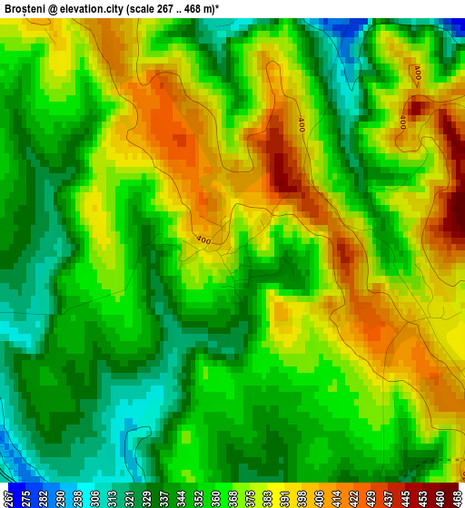
Below is the Elevation map of Broșteni, which displays elevation range with different colors. Scale of the first map is from 267 to 468 m (876 to 1535 ft) with average elevation of 364.2 meters (=1195 ft) [note 1]
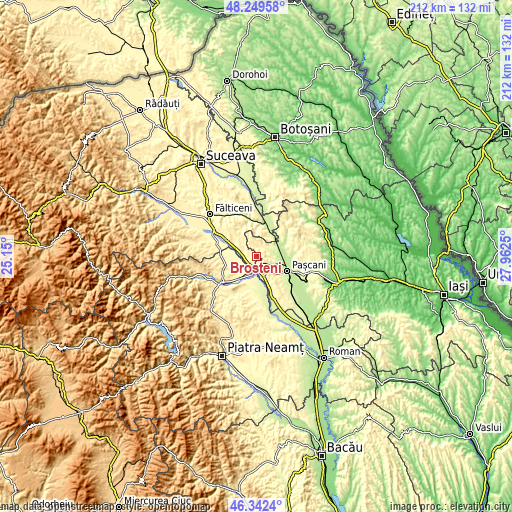
These maps also provides idea of topography and contour of this city, they are displayed at different zoom levels. More info about maps, scale and edge coordinates you can find below images.
| \ | Map #1 | Topo.Map |
| Scale [m] | 267..468 m | × |
| Scale [ft] | 876..1535 ft | × |
| Average | 364.2 m = 1195 ft | × |
| Width | 6.63 km = 4.1 mi | 212.1 km = 131.8 mi |
| Height | 6.63 km = 4.1 mi | 212 km = 131.7 mi |
| ↑Max Latitude | 47.334381° | 48.24958° |
| Latitude at center | 47.30459° | 47.30459° |
| ↓Min Latitude | 47.274782° | 46.3424° |
| ← Min Longitude | 26.512305° | 25.15° |
| Longitude center | 26.55625° | 26.55625° |
| →Max Longitude | 26.600195° | 27.9625° |
Nearby cities:
Cities around Broșteni sort by population:
• Tătăruşi elevation 338 m
6 km,  33°
33°
• Moţca 360 m
7.6 km,  143°
143°
• Forăşti 379 m
8.4 km,  306°
306°
• Cristeşti 328 m
4.3 km,  169°
169°
• Timişeşti 277 m
7.9 km,  183°
183°
• Drăguşeni 288 m
6 km,  246°
246°
• Heci 228 m
9.1 km,  61°
61°
• Valea Seacă 253 m
8.6 km,  99°
99°
• Uda 303 m
3.7 km,  18°
18°
• Conțești 236 m
7.5 km,  85°
85°
• Pietrosu 303 m
5.6 km,  43°
43°
• Oniceni 322 m
7.4 km,  287°
287°
Multilingual:
 En español:
Broșteni elevación 383 m.
 En France:
Broșteni élévation 383 m.
 Auf Deutsch:
Broșteni höhe über dem Meeresspiegel ist 383 m.

Sources and notes:
- [note 1] Map square and city borders are not equal. Map elevation data is calculated only from area inside that square.
- [src 1] Elevation data from geonames database provided with same terms of usage.
- [src 2] The elevation map of Broșteni is generated using elevation data from NASA's 3 arcsec (90m) resolution SRTM data.
- [src 3] Base (background) map © OpenStreetMap contributors tiles are generated by Geofabrik and OpenTopoMap.
Copyright & License:
This Broșteni Elevation Map is licensed under CC BY-SA. You may reuse any part from this page, if you give a proper credit by linking to this URL:
 More info on terms of use page.