Brad elevation
Brad (Hunedoara, Municipiul Brad), Romania elevation is 272 meters and Brad elevation in feet is 892 ft above sea level [src 1]. Brad is a seat of a second-order administrative division (feature code) with elevation that is 20 meters (66 ft) bigger than average city elevation in Romania.
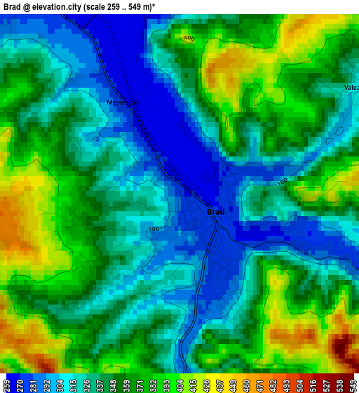
Below is the Elevation map of Brad, which displays elevation range with different colors. Scale of the first map is from 259 to 549 m (850 to 1801 ft) with average elevation of 347 meters (=1138 ft) [note 1]
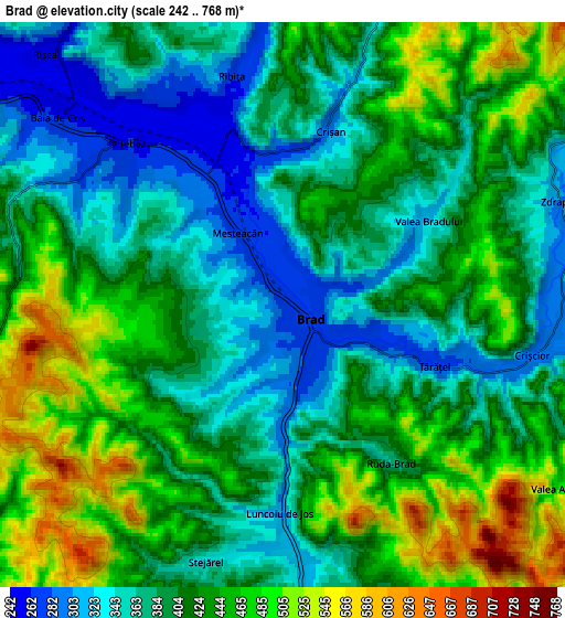
These maps also provides idea of topography and contour of this city, they are displayed at different zoom levels. More info about maps, scale and edge coordinates you can find below images.
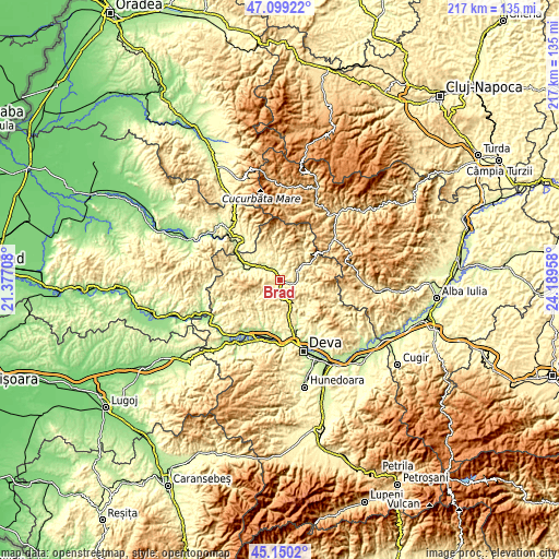
| \ | Map #1 | Map #2 | Topo.Map |
| Scale [m] | 259..549 m | 242..768 m | × |
| Scale [ft] | 850..1801 ft | 794..2520 ft | × |
| Average | 347 m = 1138 ft | 410.1 m = 1345 ft | × |
| Width | 6.77 km = 4.2 mi | 13.54 km = 8.4 mi | 216.7 km = 134.7 mi |
| Height | 6.77 km = 4.2 mi | 13.54 km = 8.4 mi | 216.7 km = 134.7 mi |
| ↑Max Latitude | 46.163775° | 46.194203° | 47.09922° |
| Latitude at center | 46.13333° | 46.13333° | 46.13333° |
| ↓Min Latitude | 46.102868° | 46.07239° | 45.1502° |
| ← Min Longitude | 22.739385° | 22.695439° | 21.37708° |
| Longitude center | 22.78333° | 22.78333° | 22.78333° |
| →Max Longitude | 22.827275° | 22.871221° | 24.18958° |
Nearby cities:
Cities around Brad sort by population:
• Crişcior elevation 336 m
6.7 km,  106°
106°
• Baia de Criş 288 m
6.3 km,  305°
305°
• Buceş 477 m
12.8 km,  64°
64°
• Barza 287 m
5.9 km,  104°
104°
• Luncoiu de Jos 424 m
3.9 km,  199°
199°
• Bucureşci 403 m
9 km,  90°
90°
• Ribiţa 277 m
5.7 km,  347°
347°
• Blăjeni 497 m
14.3 km,  38°
38°
• Vălişoara 384 m
10.6 km,  150°
150°
• Zdrapți 304 m
7.1 km,  69°
69°
• Tomeşti 305 m
13.8 km, 312°
• Hărțăgani 305 m
14.1 km,  130°
130°
Multilingual:
 En español:
Brad elevación 272 m.
 En France:
Brad élévation 272 m.


Sources and notes:
- [note 1] Map square and city borders are not equal. Map elevation data is calculated only from area inside that square.
- [src 1] Elevation data from geonames database provided with same terms of usage.
- [src 2] The elevation map of Brad is generated using elevation data from NASA's 3 arcsec (90m) resolution SRTM data.
- [src 3] Base (background) map © OpenStreetMap contributors tiles are generated by Geofabrik and OpenTopoMap.
Copyright & License:
This Brad Elevation Map is licensed under CC BY-SA. You may reuse any part from this page, if you give a proper credit by linking to this URL:
 More info on terms of use page.