Blăjeni elevation
Blăjeni (Hunedoara, Comuna Blăjeni), Romania elevation is 497 meters and Blăjeni elevation in feet is 1631 ft above sea level [src 1]. Blăjeni is a seat of a second-order administrative division (feature code) with elevation that is 245 meters (804 ft) bigger than average city elevation in Romania.
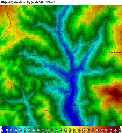
Below is the Elevation map of Blăjeni, which displays elevation range with different colors. Scale of the first map is from 342 to 968 m (1122 to 3176 ft) with average elevation of 574.8 meters (=1886 ft) [note 1]
These maps also provides idea of topography and contour of this city, they are displayed at different zoom levels. More info about maps, scale and edge coordinates you can find below images.
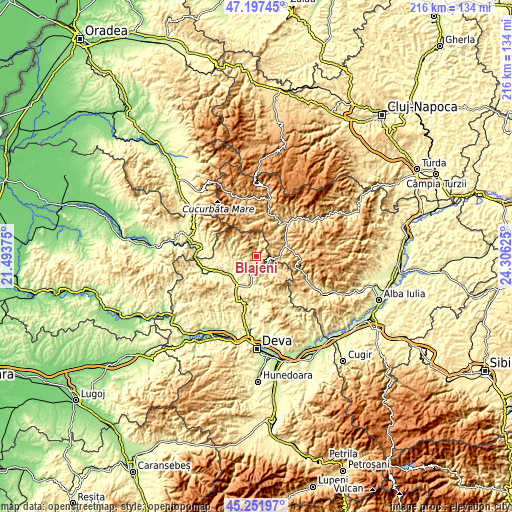
| \ | Map #1 | Topo.Map |
| Scale [m] | 342..968 m | × |
| Scale [ft] | 1122..3176 ft | × |
| Average | 574.8 m = 1886 ft | × |
| Width | 6.76 km = 4.2 mi | 216.3 km = 134.4 mi |
| Height | 6.76 km = 4.2 mi | 216.3 km = 134.4 mi |
| ↑Max Latitude | 46.26372° | 47.19745° |
| Latitude at center | 46.23333° | 46.23333° |
| ↓Min Latitude | 46.202924° | 45.25197° |
| ← Min Longitude | 22.856055° | 21.49375° |
| Longitude center | 22.9° | 22.9° |
| →Max Longitude | 22.943945° | 24.30625° |
Nearby cities:
Cities around Blăjeni sort by population:
• Brad elevation 272 m
14.3 km,  218°
218°
• Abrud 598 m
13.4 km,  70°
70°
• Crişcior 336 m
13.2 km,  191°
191°
• Buceş 477 m
6.1 km,  155°
155°
• Barza 287 m
13 km, 194°
• Bucureşci 403 m
11.1 km,  180°
180°
• Ribiţa 277 m
11.7 km,  241°
241°
• Abrud-Sat 617 m
13.5 km, 66°
• Ciuruleasa 612 m
10.4 km,  79°
79°
• Zdrapți 304 m
8.9 km,  195°
195°
• Vidra 642 m
15 km,  356°
356°
• Bulzeștii de Sus 506 m
13 km,  305°
305°
Multilingual:
 En español:
Blăjeni elevación 497 m.
 En France:
Blăjeni élévation 497 m.


Sources and notes:
- [note 1] Map square and city borders are not equal. Map elevation data is calculated only from area inside that square.
- [src 1] Elevation data from geonames database provided with same terms of usage.
- [src 2] The elevation map of Blăjeni is generated using elevation data from NASA's 3 arcsec (90m) resolution SRTM data.
- [src 3] Base (background) map © OpenStreetMap contributors tiles are generated by Geofabrik and OpenTopoMap.
Copyright & License:
This Blăjeni Elevation Map is licensed under CC BY-SA. You may reuse any part from this page, if you give a proper credit by linking to this URL:
 More info on terms of use page.