Baia de Criş elevation
Baia de Criş (Hunedoara, Comuna Baia de Criş), Romania elevation is 288 meters and Baia de Criş elevation in feet is 945 ft above sea level [src 1]. Baia de Criş is a seat of a second-order administrative division (feature code) with elevation that is 36 meters (118 ft) bigger than average city elevation in Romania.
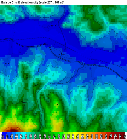
Below is the Elevation map of Baia de Criş, which displays elevation range with different colors. Scale of the first map is from 237 to 767 m (778 to 2516 ft) with average elevation of 331.6 meters (=1088 ft) [note 1]
These maps also provides idea of topography and contour of this city, they are displayed at different zoom levels. More info about maps, scale and edge coordinates you can find below images.
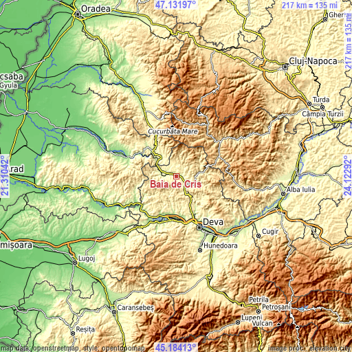
| \ | Map #1 | Topo.Map |
| Scale [m] | 237..767 m | × |
| Scale [ft] | 778..2516 ft | × |
| Average | 331.6 m = 1088 ft | × |
| Width | 6.77 km = 4.2 mi | 216.6 km = 134.6 mi |
| Height | 6.77 km = 4.2 mi | 216.6 km = 134.6 mi |
| ↑Max Latitude | 46.197096° | 47.13197° |
| Latitude at center | 46.16667° | 46.16667° |
| ↓Min Latitude | 46.136227° | 45.18413° |
| ← Min Longitude | 22.672725° | 21.31042° |
| Longitude center | 22.71667° | 22.71667° |
| →Max Longitude | 22.760615° | 24.12292° |
Nearby cities:
Cities around Baia de Criş sort by population:
• Brad elevation 272 m
6.3 km,  125°
125°
• Vaţa de Jos 228 m
9.2 km,  281°
281°
• Crişcior 336 m
12.8 km,  115°
115°
• Hălmagiu 240 m
15.1 km,  317°
317°
• Barza 287 m
12 km, 115°
• Luncoiu de Jos 424 m
8.4 km,  152°
152°
• Bucureşci 403 m
14.6 km,  104°
104°
• Hălmăgel 271 m
13.5 km,  325°
325°
• Ribiţa 277 m
4.3 km,  64°
64°
• Zdrapți 304 m
11.8 km, 95°
• Tomeşti 305 m
7.6 km, 317°
• Bulzeștii de Sus 506 m
15.3 km,  12°
12°
Multilingual:
 En español:
Baia de Criş elevación 288 m.
 En France:
Baia de Criş élévation 288 m.
 Auf Deutsch:
Baia de Criş höhe über dem Meeresspiegel ist 288 m.

Sources and notes:
- [note 1] Map square and city borders are not equal. Map elevation data is calculated only from area inside that square.
- [src 1] Elevation data from geonames database provided with same terms of usage.
- [src 2] The elevation map of Baia de Criş is generated using elevation data from NASA's 3 arcsec (90m) resolution SRTM data.
- [src 3] Base (background) map © OpenStreetMap contributors tiles are generated by Geofabrik and OpenTopoMap.
Copyright & License:
This Baia de Criş Elevation Map is licensed under CC BY-SA. You may reuse any part from this page, if you give a proper credit by linking to this URL:
 More info on terms of use page.