Breaza elevation
Breaza (Buzău, Comuna Breaza), Romania elevation is 418 meters and Breaza elevation in feet is 1371 ft above sea level [src 1]. Breaza is a seat of a second-order administrative division (feature code) with elevation that is 166 meters (545 ft) bigger than average city elevation in Romania.
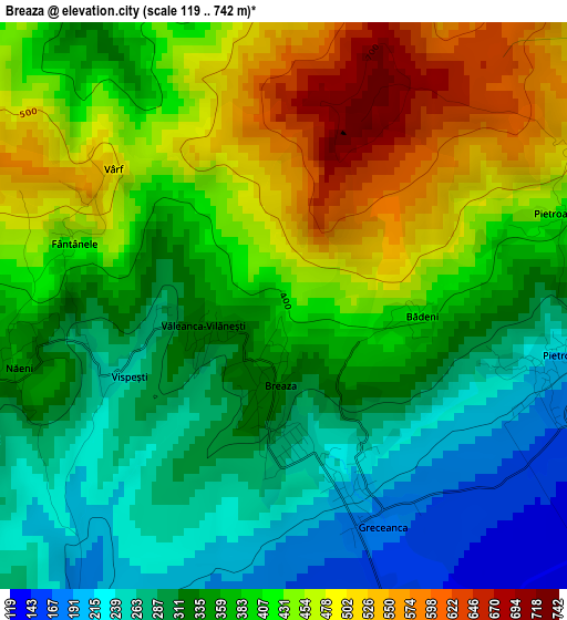
Below is the Elevation map of Breaza, which displays elevation range with different colors. Scale of the first map is from 119 to 742 m (390 to 2434 ft) with average elevation of 377.5 meters (=1239 ft) [note 1]
These maps also provides idea of topography and contour of this city, they are displayed at different zoom levels. More info about maps, scale and edge coordinates you can find below images.
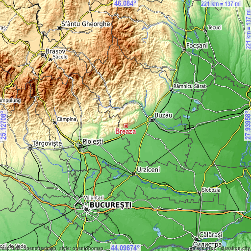
| \ | Map #1 | Topo.Map |
| Scale [m] | 119..742 m | × |
| Scale [ft] | 390..2434 ft | × |
| Average | 377.5 m = 1239 ft | × |
| Width | 6.9 km = 4.3 mi | 220.7 km = 137.1 mi |
| Height | 6.9 km = 4.3 mi | 220.7 km = 137.1 mi |
| ↑Max Latitude | 45.131011° | 46.084° |
| Latitude at center | 45.1° | 45.1° |
| ↓Min Latitude | 45.068972° | 44.09874° |
| ← Min Longitude | 26.489385° | 25.12708° |
| Longitude center | 26.53333° | 26.53333° |
| →Max Longitude | 26.577275° | 27.93958° |
Nearby cities:
Cities around Breaza sort by population:
• Mizil elevation 124 m
11.3 km,  215°
215°
• Pietroasele 341 m
2.6 km,  90°
90°
• Săhăteni 124 m
7.5 km,  190°
190°
• Ulmeni 100 m
9.9 km,  112°
112°
• Gura Vadului 189 m
7.6 km, 223°
• Năeni 345 m
3.9 km,  270°
270°
• Vâlcele 119 m
8 km,  100°
100°
• Greceanca 195 m
2.5 km,  159°
159°
• Perșunari 185 m
8.3 km,  234°
234°
• Lapoș 328 m
10.7 km,  302°
302°
• Jugureni 451 m
6.5 km, 270°
• Izvoru 179 m
11.3 km,  23°
23°
Multilingual:
 En español:
Breaza elevación 418 m.
 En France:
Breaza élévation 418 m.


Sources and notes:
- [note 1] Map square and city borders are not equal. Map elevation data is calculated only from area inside that square.
- [src 1] Elevation data from geonames database provided with same terms of usage.
- [src 2] The elevation map of Breaza is generated using elevation data from NASA's 3 arcsec (90m) resolution SRTM data.
- [src 3] Base (background) map © OpenStreetMap contributors tiles are generated by Geofabrik and OpenTopoMap.
Copyright & License:
This Breaza Elevation Map is licensed under CC BY-SA. You may reuse any part from this page, if you give a proper credit by linking to this URL:
 More info on terms of use page.