Perșunari elevation
Perșunari (Prahova, Comuna Gura Vadului), Romania elevation is 185 meters and Perșunari elevation in feet is 607 ft above sea level [src 1]. Perșunari is a populated place (feature code) with elevation that is 67 meters (220 ft) smaller than average city elevation in Romania.
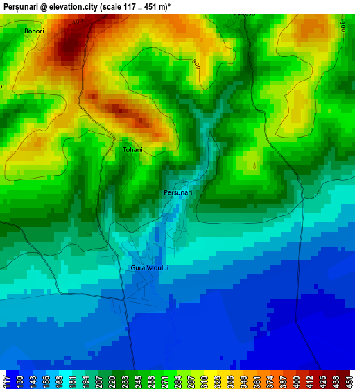
Below is the Elevation map of Perșunari, which displays elevation range with different colors. Scale of the first map is from 117 to 451 m (384 to 1480 ft) with average elevation of 226 meters (=741 ft) [note 1]
These maps also provides idea of topography and contour of this city, they are displayed at different zoom levels. More info about maps, scale and edge coordinates you can find below images.
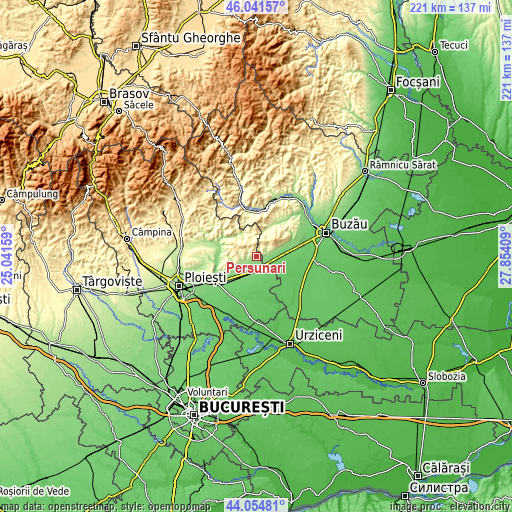
| \ | Map #1 | Topo.Map |
| Scale [m] | 117..451 m | × |
| Scale [ft] | 384..1480 ft | × |
| Average | 226 m = 741 ft | × |
| Width | 6.9 km = 4.3 mi | 220.9 km = 137.3 mi |
| Height | 6.9 km = 4.3 mi | 220.9 km = 137.3 mi |
| ↑Max Latitude | 45.087855° | 46.04157° |
| Latitude at center | 45.05682° | 45.05682° |
| ↓Min Latitude | 45.025768° | 44.05481° |
| ← Min Longitude | 26.403895° | 25.04159° |
| Longitude center | 26.44784° | 26.44784° |
| →Max Longitude | 26.491785° | 27.85409° |
Nearby cities:
Cities around Perșunari sort by population:
• Mizil elevation 124 m
4.5 km,  177°
177°
• Baba Ana 99 m
10 km, 179°
• Săhăteni 124 m
6 km,  115°
115°
• Breaza 418 m
8.3 km,  54°
54°
• Gura Vadului 189 m
1.7 km, 117°
• Fântânele 135 m
7.8 km,  225°
225°
• Năeni 345 m
5.6 km,  30°
30°
• Călugăreni 373 m
5.9 km,  300°
300°
• Conduratu 108 m
9.5 km,  186°
186°
• Greceanca 195 m
8 km,  72°
72°
• Vadu Săpat 169 m
5.1 km,  248°
248°
• Jugureni 451 m
4.8 km,  2°
2°
Multilingual:
 En español:
Perșunari elevación 185 m.
 En France:
Perșunari élévation 185 m.
 Auf Deutsch:
Perșunari höhe über dem Meeresspiegel ist 185 m.

Sources and notes:
- [note 1] Map square and city borders are not equal. Map elevation data is calculated only from area inside that square.
- [src 1] Elevation data from geonames database provided with same terms of usage.
- [src 2] The elevation map of Perșunari is generated using elevation data from NASA's 3 arcsec (90m) resolution SRTM data.
- [src 3] Base (background) map © OpenStreetMap contributors tiles are generated by Geofabrik and OpenTopoMap.
Copyright & License:
This Perșunari Elevation Map is licensed under CC BY-SA. You may reuse any part from this page, if you give a proper credit by linking to this URL:
 More info on terms of use page.