Mizil elevation
Mizil (Prahova, Oraş Mizil), Romania elevation is 124 meters and Mizil elevation in feet is 407 ft above sea level [src 1]. Mizil is a seat of a second-order administrative division (feature code) with elevation that is 128 meters (420 ft) smaller than average city elevation in Romania.
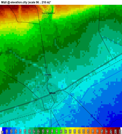
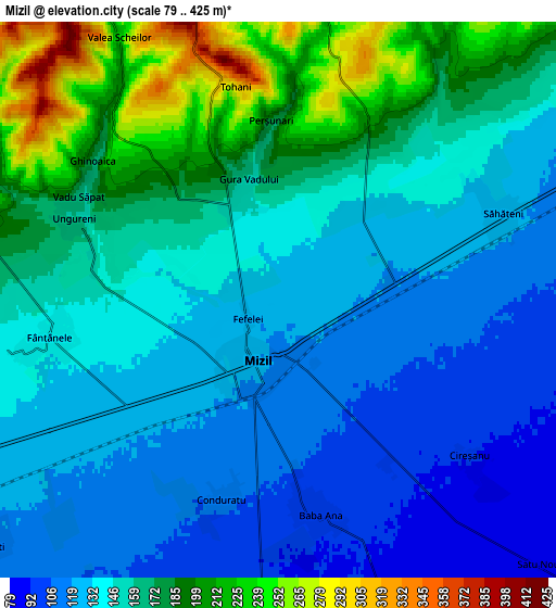
Below is the Elevation map of Mizil, which displays elevation range with different colors. Scale of the first map is from 96 to 210 m (315 to 689 ft) with average elevation of 129.4 meters (=425 ft) [note 1]
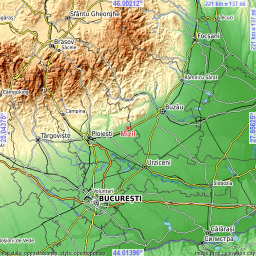
These maps also provides idea of topography and contour of this city, they are displayed at different zoom levels. More info about maps, scale and edge coordinates you can find below images.
| \ | Map #1 | Map #2 | Topo.Map |
| Scale [m] | 96..210 m | 79..425 m | × |
| Scale [ft] | 315..689 ft | 259..1394 ft | × |
| Average | 129.4 m = 425 ft | 152 m = 499 ft | × |
| Width | 6.91 km = 4.3 mi | 13.82 km = 8.6 mi | 221.1 km = 137.4 mi |
| Height | 6.91 km = 4.3 mi | 13.82 km = 8.6 mi | 221.1 km = 137.4 mi |
| ↑Max Latitude | 45.047727° | 45.078766° | 46.00212° |
| Latitude at center | 45.01667° | 45.01667° | 45.01667° |
| ↓Min Latitude | 44.985597° | 44.954506° | 44.01396° |
| ← Min Longitude | 26.406055° | 26.362109° | 25.04375° |
| Longitude center | 26.45° | 26.45° | 26.45° |
| →Max Longitude | 26.493945° | 26.537891° | 27.85625° |
Nearby cities:
Cities around Mizil sort by population:
• Baba Ana elevation 99 m
5.6 km,  180°
180°
• Săhăteni 124 m
5.6 km,  70°
70°
• Ceptura de Jos 168 m
9.7 km,  272°
272°
• Gura Vadului 189 m
3.9 km,  19°
19°
• Fântânele 135 m
5.8 km,  259°
259°
• Inotești 114 m
9.5 km,  229°
229°
• Năeni 345 m
9.6 km, 15°
• Călugăreni 373 m
9.1 km,  324°
324°
• Conduratu 108 m
5.1 km,  194°
194°
• Perșunari 185 m
4.5 km,  357°
357°
• Vadu Săpat 169 m
5.6 km,  297°
297°
• Jugureni 451 m
9.3 km,  0°
0°
Multilingual:
 En español:
Mizil elevación 124 m.
 En France:
Mizil élévation 124 m.


Sources and notes:
- [note 1] Map square and city borders are not equal. Map elevation data is calculated only from area inside that square.
- [src 1] Elevation data from geonames database provided with same terms of usage.
- [src 2] The elevation map of Mizil is generated using elevation data from NASA's 3 arcsec (90m) resolution SRTM data.
- [src 3] Base (background) map © OpenStreetMap contributors tiles are generated by Geofabrik and OpenTopoMap.
Copyright & License:
This Mizil Elevation Map is licensed under CC BY-SA. You may reuse any part from this page, if you give a proper credit by linking to this URL:
 More info on terms of use page.