Buda elevation
Buda (Buzău, Comuna Buda), Romania elevation is 284 meters and Buda elevation in feet is 932 ft above sea level [src 1]. Buda is a seat of a second-order administrative division (feature code) with elevation that is 32 meters (105 ft) bigger than average city elevation in Romania.
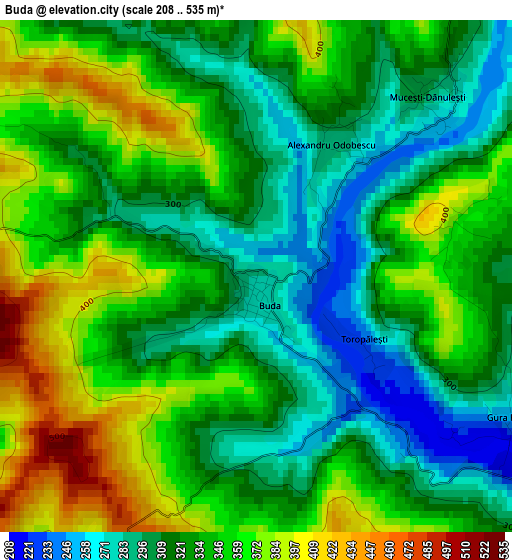
Below is the Elevation map of Buda, which displays elevation range with different colors. Scale of the first map is from 208 to 535 m (682 to 1755 ft) with average elevation of 334.6 meters (=1098 ft) [note 1]
These maps also provides idea of topography and contour of this city, they are displayed at different zoom levels. More info about maps, scale and edge coordinates you can find below images.
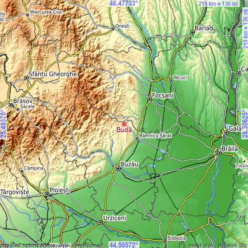
| \ | Map #1 | Topo.Map |
| Scale [m] | 208..535 m | × |
| Scale [ft] | 682..1755 ft | × |
| Average | 334.6 m = 1098 ft | × |
| Width | 6.85 km = 4.3 mi | 219.2 km = 136.2 mi |
| Height | 6.85 km = 4.3 mi | 219.2 km = 136.2 mi |
| ↑Max Latitude | 45.530793° | 46.47703° |
| Latitude at center | 45.5° | 45.5° |
| ↓Min Latitude | 45.46919° | 44.50572° |
| ← Min Longitude | 26.856055° | 25.49375° |
| Longitude center | 26.9° | 26.9° |
| →Max Longitude | 26.943945° | 28.30625° |
Nearby cities:
Cities around Buda sort by population:
• Slobozia Bradului elevation 171 m
11.7 km,  90°
90°
• Chiojdeni 489 m
6.1 km,  334°
334°
• Cornetu 161 m
11.9 km, 87°
• Săruleşti 452 m
11.7 km,  270°
270°
• Coțatcu 276 m
9.7 km,  112°
112°
• Murgeşti 292 m
11.2 km,  186°
186°
• Băbeni 252 m
8.6 km,  134°
134°
• Dedulești 198 m
6.2 km,  122°
122°
• Mărgăriteşti 402 m
9.1 km,  215°
215°
• Dumitrești 292 m
6.2 km,  20°
20°
• Valea Salciei 402 m
6 km, 265°
• Tâmboeşti 183 m
11.8 km,  80°
80°
Multilingual:
 En español:
Buda elevación 284 m.
 En France:
Buda élévation 284 m.


Sources and notes:
- [note 1] Map square and city borders are not equal. Map elevation data is calculated only from area inside that square.
- [src 1] Elevation data from geonames database provided with same terms of usage.
- [src 2] The elevation map of Buda is generated using elevation data from NASA's 3 arcsec (90m) resolution SRTM data.
- [src 3] Base (background) map © OpenStreetMap contributors tiles are generated by Geofabrik and OpenTopoMap.
Copyright & License:
This Buda Elevation Map is licensed under CC BY-SA. You may reuse any part from this page, if you give a proper credit by linking to this URL:
 More info on terms of use page.