Tâmboeşti elevation
Tâmboeşti (Vrancea, Comuna Tâmboeşti), Romania elevation is 183 meters and Tâmboeşti elevation in feet is 600 ft above sea level [src 1]. Tâmboeşti is a seat of a second-order administrative division (feature code) with elevation that is 69 meters (226 ft) smaller than average city elevation in Romania.
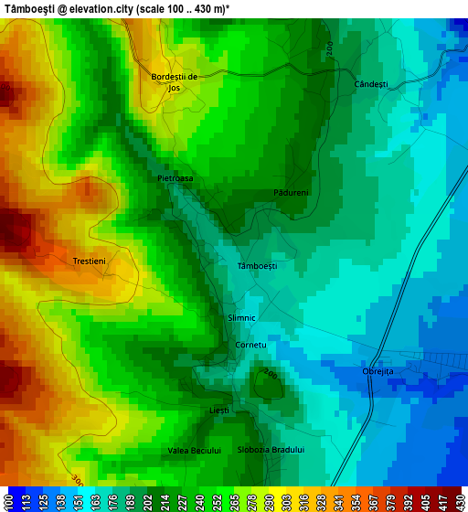
Below is the Elevation map of Tâmboeşti, which displays elevation range with different colors. Scale of the first map is from 100 to 430 m (328 to 1411 ft) with average elevation of 224.1 meters (=735 ft) [note 1]
These maps also provides idea of topography and contour of this city, they are displayed at different zoom levels. More info about maps, scale and edge coordinates you can find below images.
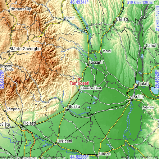
| \ | Map #1 | Topo.Map |
| Scale [m] | 100..430 m | × |
| Scale [ft] | 328..1411 ft | × |
| Average | 224.1 m = 735 ft | × |
| Width | 6.85 km = 4.3 mi | 219.1 km = 136.1 mi |
| Height | 6.85 km = 4.3 mi | 219.1 km = 136.1 mi |
| ↑Max Latitude | 45.547454° | 46.49341° |
| Latitude at center | 45.51667° | 45.51667° |
| ↓Min Latitude | 45.485869° | 44.52268° |
| ← Min Longitude | 27.006055° | 25.64375° |
| Longitude center | 27.05° | 27.05° |
| →Max Longitude | 27.093945° | 28.45625° |
Nearby cities:
Cities around Tâmboeşti sort by population:
• Gugeşti elevation 81 m
8.5 km,  49°
49°
• Urecheşti 164 m
9.4 km,  7°
7°
• Sihlea 107 m
5.5 km,  109°
109°
• Slobozia Bradului 171 m
1.9 km,  180°
180°
• Dumbrăveni 112 m
5.5 km,  70°
70°
• Gura Caliţei 166 m
7.9 km,  340°
340°
• Popești 159 m
9 km, 14°
• Cornetu 161 m
1.4 km,  169°
169°
• Bordeşti 230 m
3.7 km,  0°
0°
• Coțatcu 276 m
6.2 km,  206°
206°
• Obrejița 131 m
3.6 km,  119°
119°
• Dedulești 198 m
8.3 km,  231°
231°
Multilingual:
 En español:
Tâmboeşti elevación 183 m.
 En France:
Tâmboeşti élévation 183 m.
 Auf Deutsch:
Tâmboeşti höhe über dem Meeresspiegel ist 183 m.

Sources and notes:
- [note 1] Map square and city borders are not equal. Map elevation data is calculated only from area inside that square.
- [src 1] Elevation data from geonames database provided with same terms of usage.
- [src 2] The elevation map of Tâmboeşti is generated using elevation data from NASA's 3 arcsec (90m) resolution SRTM data.
- [src 3] Base (background) map © OpenStreetMap contributors tiles are generated by Geofabrik and OpenTopoMap.
Copyright & License:
This Tâmboeşti Elevation Map is licensed under CC BY-SA. You may reuse any part from this page, if you give a proper credit by linking to this URL:
 More info on terms of use page.