Bulz elevation
Bulz (Bihor, Comuna Bulz), Romania elevation is 568 meters and Bulz elevation in feet is 1864 ft above sea level [src 1]. Bulz is a seat of a second-order administrative division (feature code) with elevation that is 316 meters (1037 ft) bigger than average city elevation in Romania.
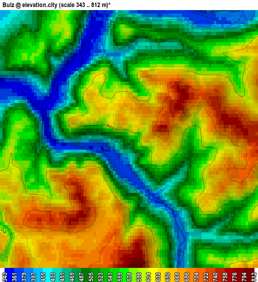
Below is the Elevation map of Bulz, which displays elevation range with different colors. Scale of the first map is from 343 to 812 m (1125 to 2664 ft) with average elevation of 564.2 meters (=1851 ft) [note 1]
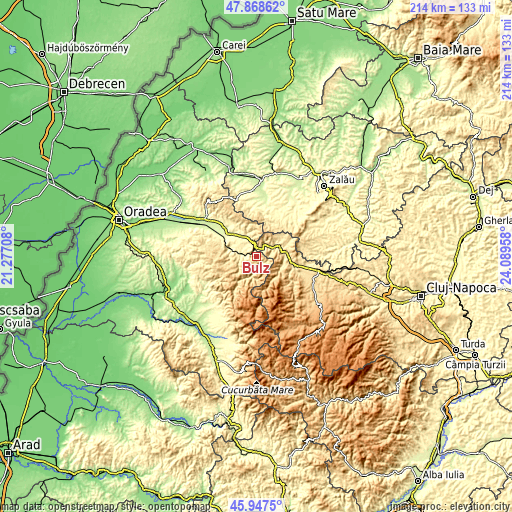
These maps also provides idea of topography and contour of this city, they are displayed at different zoom levels. More info about maps, scale and edge coordinates you can find below images.
| \ | Map #1 | Topo.Map |
| Scale [m] | 343..812 m | × |
| Scale [ft] | 1125..2664 ft | × |
| Average | 564.2 m = 1851 ft | × |
| Width | 6.68 km = 4.2 mi | 213.6 km = 132.7 mi |
| Height | 6.68 km = 4.2 mi | 213.6 km = 132.7 mi |
| ↑Max Latitude | 46.946679° | 47.86862° |
| Latitude at center | 46.91667° | 46.91667° |
| ↓Min Latitude | 46.886644° | 45.9475° |
| ← Min Longitude | 22.639385° | 21.27708° |
| Longitude center | 22.68333° | 22.68333° |
| →Max Longitude | 22.727275° | 24.08958° |
Nearby cities:
Cities around Bulz sort by population:
• Bratca elevation 381 m
5.4 km,  290°
290°
• Ciucea 478 m
10.8 km,  69°
69°
• Vadu Crişului 277 m
14.7 km,  300°
300°
• Borod 379 m
8.3 km,  332°
332°
• Şuncuiuş 507 m
11.5 km,  279°
279°
• Auşeu 252 m
19 km,  313°
313°
• Negreni 428 m
7.4 km,  55°
55°
• Beznea 366 m
6.8 km, 314°
• Luncșoara 303 m
17.1 km,  321°
321°
• Bălnaca 379 m
9 km, 289°
• Poieni 479 m
13.3 km,  88°
88°
• Săcuieu 620 m
18.7 km,  123°
123°
Multilingual:
 En español:
Bulz elevación 568 m.
 En France:
Bulz élévation 568 m.


Sources and notes:
- [note 1] Map square and city borders are not equal. Map elevation data is calculated only from area inside that square.
- [src 1] Elevation data from geonames database provided with same terms of usage.
- [src 2] The elevation map of Bulz is generated using elevation data from NASA's 3 arcsec (90m) resolution SRTM data.
- [src 3] Base (background) map © OpenStreetMap contributors tiles are generated by Geofabrik and OpenTopoMap.
Copyright & License:
This Bulz Elevation Map is licensed under CC BY-SA. You may reuse any part from this page, if you give a proper credit by linking to this URL:
 More info on terms of use page.