Călmăţuiu elevation
Călmăţuiu (Teleorman, Comuna Cãlmãţuiu), Romania elevation is 70 meters and Călmăţuiu elevation in feet is 230 ft above sea level [src 1]. Călmăţuiu is a seat of a second-order administrative division (feature code) with elevation that is 182 meters (597 ft) smaller than average city elevation in Romania.
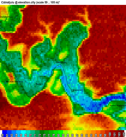
Below is the Elevation map of Călmăţuiu, which displays elevation range with different colors. Scale of the first map is from 59 to 105 m (194 to 344 ft) with average elevation of 88.5 meters (=290 ft) [note 1]
These maps also provides idea of topography and contour of this city, they are displayed at different zoom levels. More info about maps, scale and edge coordinates you can find below images.
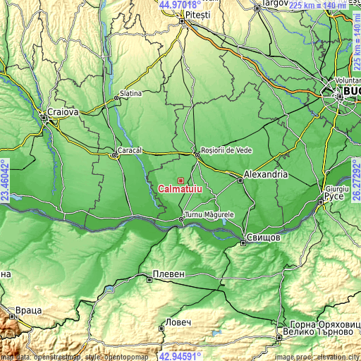
| \ | Map #1 | Topo.Map |
| Scale [m] | 59..105 m | × |
| Scale [ft] | 194..344 ft | × |
| Average | 88.5 m = 290 ft | × |
| Width | 7.03 km = 4.4 mi | 225.1 km = 139.9 mi |
| Height | 7.03 km = 4.4 mi | 225.1 km = 139.9 mi |
| ↑Max Latitude | 43.998291° | 44.97018° |
| Latitude at center | 43.96667° | 43.96667° |
| ↓Min Latitude | 43.935032° | 42.94591° |
| ← Min Longitude | 24.822725° | 23.46042° |
| Longitude center | 24.86667° | 24.86667° |
| →Max Longitude | 24.910615° | 26.27292° |
Nearby cities:
Cities around Călmăţuiu sort by population:
• Plopii Slăviţeştí elevation 70 m
14.7 km,  270°
270°
• Slobozia-Mândra 78 m
14.5 km,  247°
247°
• Crângeni 102 m
10 km,  318°
318°
• Troianul 96 m
11.3 km,  70°
70°
• Salcia 60 m
4.4 km,  114°
114°
• Putineiu 70 m
10.9 km,  132°
132°
• Băcălești 92 m
11.1 km,  338°
338°
• Brâncoveanca 67 m
14.2 km,  258°
258°
• Băneasa 59 m
7.3 km, 114°
• Băduleasa 55 m
10.5 km,  117°
117°
• Tudor Vladimirescu 75 m
3.8 km, 123°
• Călmățuiu de Sus 88 m
7.9 km,  326°
326°
Multilingual:
 En español:
Călmăţuiu elevación 70 m.
 En France:
Călmăţuiu élévation 70 m.
 Auf Deutsch:
Călmăţuiu höhe über dem Meeresspiegel ist 70 m.

Sources and notes:
- [note 1] Map square and city borders are not equal. Map elevation data is calculated only from area inside that square.
- [src 1] Elevation data from geonames database provided with same terms of usage.
- [src 2] The elevation map of Călmăţuiu is generated using elevation data from NASA's 3 arcsec (90m) resolution SRTM data.
- [src 3] Base (background) map © OpenStreetMap contributors tiles are generated by Geofabrik and OpenTopoMap.
Copyright & License:
This Călmăţuiu Elevation Map is licensed under CC BY-SA. You may reuse any part from this page, if you give a proper credit by linking to this URL:
 More info on terms of use page.