Troianul elevation
Troianul (Teleorman, Comuna Troianul), Romania elevation is 96 meters and Troianul elevation in feet is 315 ft above sea level [src 1]. Troianul is a seat of a second-order administrative division (feature code) with elevation that is 156 meters (512 ft) smaller than average city elevation in Romania.
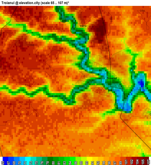
Below is the Elevation map of Troianul, which displays elevation range with different colors. Scale of the first map is from 65 to 107 m (213 to 351 ft) with average elevation of 94.5 meters (=310 ft) [note 1]
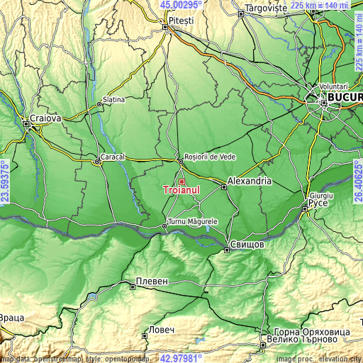
These maps also provides idea of topography and contour of this city, they are displayed at different zoom levels. More info about maps, scale and edge coordinates you can find below images.
| \ | Map #1 | Topo.Map |
| Scale [m] | 65..107 m | × |
| Scale [ft] | 213..351 ft | × |
| Average | 94.5 m = 310 ft | × |
| Width | 7.03 km = 4.4 mi | 225 km = 139.8 mi |
| Height | 7.03 km = 4.4 mi | 224.9 km = 139.7 mi |
| ↑Max Latitude | 44.031603° | 45.00295° |
| Latitude at center | 44° | 44° |
| ↓Min Latitude | 43.96838° | 42.97981° |
| ← Min Longitude | 24.956055° | 23.59375° |
| Longitude center | 25° | 25° |
| →Max Longitude | 25.043945° | 26.40625° |
Nearby cities:
Cities around Troianul sort by population:
• Roșiorii de Vede elevation 85 m
13 km,  354°
354°
• Peretu 70 m
8.7 km,  50°
50°
• Plosca 65 m
11.3 km,  70°
70°
• Măldăeni 97 m
14 km,  337°
337°
• Salcia 60 m
8.7 km,  230°
230°
• Vedea 71 m
10.7 km,  29°
29°
• Bogdana 79 m
10 km,  138°
138°
• Putineiu 70 m
11.4 km,  193°
193°
• Călmăţuiu 70 m
11.3 km,  250°
250°
• Băneasa 59 m
7.8 km,  210°
210°
• Băduleasa 55 m
8.7 km, 189°
• Tudor Vladimirescu 75 m
9.5 km, 232°
Multilingual:
 En español:
Troianul elevación 96 m.
 En France:
Troianul élévation 96 m.


Sources and notes:
- [note 1] Map square and city borders are not equal. Map elevation data is calculated only from area inside that square.
- [src 1] Elevation data from geonames database provided with same terms of usage.
- [src 2] The elevation map of Troianul is generated using elevation data from NASA's 3 arcsec (90m) resolution SRTM data.
- [src 3] Base (background) map © OpenStreetMap contributors tiles are generated by Geofabrik and OpenTopoMap.
Copyright & License:
This Troianul Elevation Map is licensed under CC BY-SA. You may reuse any part from this page, if you give a proper credit by linking to this URL:
 More info on terms of use page.