Ceptura de Sus elevation
Ceptura de Sus (Prahova, Comuna Ceptura), Romania elevation is 222 meters and Ceptura de Sus elevation in feet is 728 ft above sea level [src 1]. Ceptura de Sus is a populated place (feature code) with elevation that is 30 meters (98 ft) smaller than average city elevation in Romania.
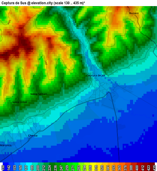
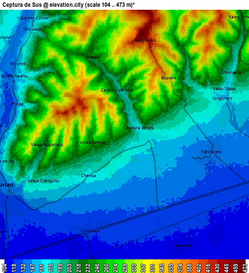
Below is the Elevation map of Ceptura de Sus, which displays elevation range with different colors. Scale of the first map is from 130 to 435 m (427 to 1427 ft) with average elevation of 222.1 meters (=729 ft) [note 1]
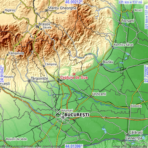
These maps also provides idea of topography and contour of this city, they are displayed at different zoom levels. More info about maps, scale and edge coordinates you can find below images.
| \ | Map #1 | Map #2 | Topo.Map |
| Scale [m] | 130..435 m | 104..473 m | × |
| Scale [ft] | 427..1427 ft | 341..1552 ft | × |
| Average | 222.1 m = 729 ft | 201.7 m = 662 ft | × |
| Width | 6.91 km = 4.3 mi | 13.82 km = 8.6 mi | 221.1 km = 137.4 mi |
| Height | 6.91 km = 4.3 mi | 13.82 km = 8.6 mi | 221.1 km = 137.4 mi |
| ↑Max Latitude | 45.047727° | 45.078766° | 46.00212° |
| Latitude at center | 45.01667° | 45.01667° | 45.01667° |
| ↓Min Latitude | 44.985597° | 44.954506° | 44.01396° |
| ← Min Longitude | 26.272725° | 26.228779° | 24.91042° |
| Longitude center | 26.31667° | 26.31667° | 26.31667° |
| →Max Longitude | 26.360615° | 26.404561° | 27.72292° |
Nearby cities:
Cities around Ceptura de Sus sort by population:
• Urlaţi elevation 125 m
7.5 km,  240°
240°
• Colceag 107 m
7.9 km,  160°
160°
• Moceşti 212 m
6.4 km,  305°
305°
• Tomşani 109 m
7.9 km,  199°
199°
• Gornet-Cricov 241 m
8.4 km,  332°
332°
• Ceptura de Jos 168 m
1 km,  60°
60°
• Fântânele 135 m
4.9 km,  102°
102°
• Inotești 114 m
6.9 km,  152°
152°
• Loloiasca 122 m
5.8 km, 200°
• Valea Cucului 169 m
8.8 km, 307°
• Vadu Săpat 169 m
6.1 km,  65°
65°
• Iordăcheanu 148 m
6.8 km,  296°
296°
Multilingual:
 En español:
Ceptura de Sus elevación 222 m.
 En France:
Ceptura de Sus élévation 222 m.
 Auf Deutsch:
Ceptura de Sus höhe über dem Meeresspiegel ist 222 m.

Sources and notes:
- [note 1] Map square and city borders are not equal. Map elevation data is calculated only from area inside that square.
- [src 1] Elevation data from geonames database provided with same terms of usage.
- [src 2] The elevation map of Ceptura de Sus is generated using elevation data from NASA's 3 arcsec (90m) resolution SRTM data.
- [src 3] Base (background) map © OpenStreetMap contributors tiles are generated by Geofabrik and OpenTopoMap.
Copyright & License:
This Ceptura de Sus Elevation Map is licensed under CC BY-SA. You may reuse any part from this page, if you give a proper credit by linking to this URL:
 More info on terms of use page.