Tomşani elevation
Tomşani (Prahova, Comuna Tomşani), Romania elevation is 109 meters and Tomşani elevation in feet is 358 ft above sea level [src 1]. Tomşani is a seat of a second-order administrative division (feature code) with elevation that is 143 meters (469 ft) smaller than average city elevation in Romania.
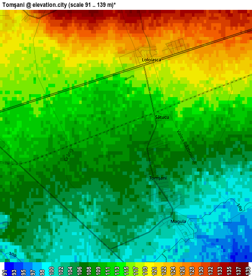
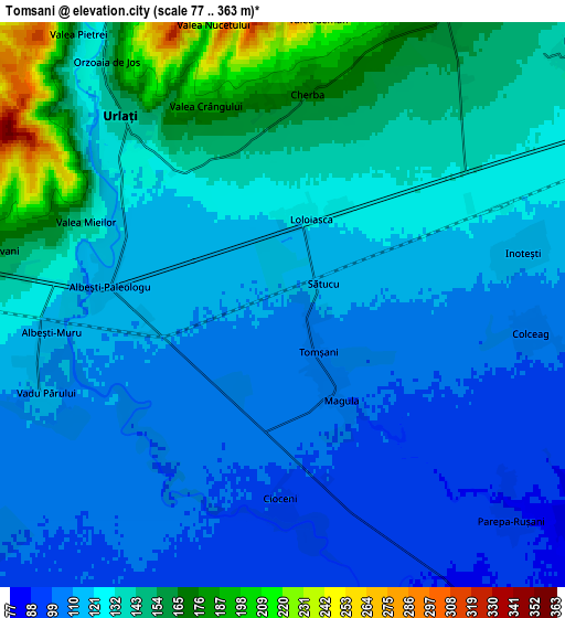
Below is the Elevation map of Tomşani, which displays elevation range with different colors. Scale of the first map is from 91 to 139 m (299 to 456 ft) with average elevation of 111.5 meters (=366 ft) [note 1]
These maps also provides idea of topography and contour of this city, they are displayed at different zoom levels. More info about maps, scale and edge coordinates you can find below images.
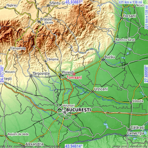
| \ | Map #1 | Map #2 | Topo.Map |
| Scale [m] | 91..139 m | 77..363 m | × |
| Scale [ft] | 299..456 ft | 253..1191 ft | × |
| Average | 111.5 m = 366 ft | 125.6 m = 412 ft | × |
| Width | 6.92 km = 4.3 mi | 13.83 km = 8.6 mi | 221.3 km = 137.5 mi |
| Height | 6.92 km = 4.3 mi | 13.83 km = 8.6 mi | 221.3 km = 137.5 mi |
| ↑Max Latitude | 44.981093° | 45.012169° | 45.93661° |
| Latitude at center | 44.95° | 44.95° | 44.95° |
| ↓Min Latitude | 44.91889° | 44.887764° | 43.94614° |
| ← Min Longitude | 26.239385° | 26.195439° | 24.87708° |
| Longitude center | 26.28333° | 26.28333° | 26.28333° |
| →Max Longitude | 26.327275° | 26.371221° | 27.68958° |
Nearby cities:
Cities around Tomşani sort by population:
• Urlaţi elevation 125 m
5.4 km,  313°
313°
• Albeşti-Paleologu 116 m
5.2 km,  270°
270°
• Colceag 107 m
5.2 km,  90°
90°
• Ceptura de Sus 222 m
7.9 km,  19°
19°
• Ceptura de Jos 168 m
8.6 km, 23°
• Fântânele 135 m
9.7 km,  49°
49°
• Vadu Părului 111 m
6.2 km,  250°
250°
• Inotești 114 m
6 km,  77°
77°
• Magula 101 m
2.5 km,  145°
145°
• Loloiasca 122 m
2.1 km, 17°
• Parepa-Rușani 86 m
7.5 km,  131°
131°
• Albești-Muru 117 m
5.9 km,  263°
263°
Multilingual:
 En español:
Tomşani elevación 109 m.
 En France:
Tomşani élévation 109 m.


Sources and notes:
- [note 1] Map square and city borders are not equal. Map elevation data is calculated only from area inside that square.
- [src 1] Elevation data from geonames database provided with same terms of usage.
- [src 2] The elevation map of Tomşani is generated using elevation data from NASA's 3 arcsec (90m) resolution SRTM data.
- [src 3] Base (background) map © OpenStreetMap contributors tiles are generated by Geofabrik and OpenTopoMap.
Copyright & License:
This Tomşani Elevation Map is licensed under CC BY-SA. You may reuse any part from this page, if you give a proper credit by linking to this URL:
 More info on terms of use page.